You are here: Home > Network List > N4 - Central and EAstern US Network Stations List
> Station K38B Parkersburg, IA, USA > Earthquake Result Viewer
K38B Parkersburg, IA, USA - Earthquake Result Viewer
| Earthquake location: |
Southern Alaska |
| Earthquake latitude/longitude: |
59.9/-153.1 |
| Earthquake time(UTC): |
2015/07/29 (210) 02:35:58 GMT |
| Earthquake Depth: |
118 km |
| Earthquake Magnitude: |
6.3 ML, 6.2 MWP, 6.2 MI, 6.3 MWW |
| Earthquake Catalog/Contributor: |
NEIC PDE/NEIC COMCAT |
|
| Network: |
N4 Central and EAstern US Network |
| Station: |
K38B Parkersburg, IA, USA |
| Lat/Lon: |
42.65 N/92.77 W |
| Elevation: |
307 m |
|
| Distance: |
39.9 deg |
| Az: |
87.805 deg |
| Baz: |
316.944 deg |
| Ray Param: |
0.0743154 |
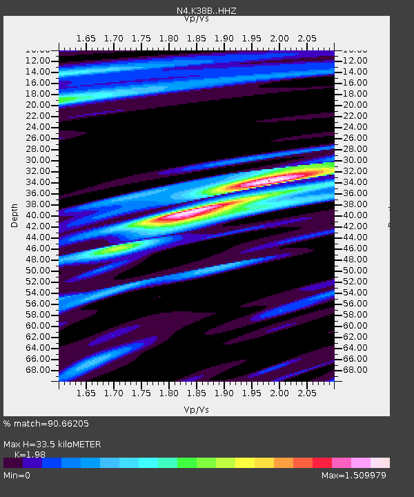
| Estimated Moho Depth: |
33.5 km |
| Estimated Crust Vp/Vs: |
1.98 |
| Assumed Crust Vp: |
6.53 km/s |
| Estimated Crust Vs: |
3.298 km/s |
| Estimated Crust Poisson's Ratio: |
0.33 |
|
| Radial Match: |
90.66205 % |
| Radial Bump: |
400 |
| Transverse Match: |
77.29824 % |
| Transverse Bump: |
400 |
| SOD ConfigId: |
7422571 |
| Insert Time: |
2019-04-20 01:46:39.460 +0000 |
| GWidth: |
2.5 |
| Max Bumps: |
400 |
| Tol: |
0.001 |
|

Signal To Noise
| Channel | StoN | STA | LTA |
| N4:K38B: :HHZ:20150729T02:42:50.73999Z | 17.577438 | 2.0497625E-6 | 1.1661327E-7 |
| N4:K38B: :HHN:20150729T02:42:50.73999Z | 4.621157 | 6.20314E-7 | 1.3423347E-7 |
| N4:K38B: :HHE:20150729T02:42:50.73999Z | 5.5919952 | 5.122869E-7 | 9.161076E-8 |
| Arrivals |
| Ps | 5.4 SECOND |
| PpPs | 14 SECOND |
| PsPs/PpSs | 20 SECOND |


