You are here: Home > Network List > N4 - Central and EAstern US Network Stations List
> Station N49A Columbus Grove, OH, USA > Earthquake Result Viewer
N49A Columbus Grove, OH, USA - Earthquake Result Viewer
| Earthquake location: |
Southern Alaska |
| Earthquake latitude/longitude: |
59.9/-153.1 |
| Earthquake time(UTC): |
2015/07/29 (210) 02:35:58 GMT |
| Earthquake Depth: |
118 km |
| Earthquake Magnitude: |
6.3 ML, 6.2 MWP, 6.2 MI, 6.3 MWW |
| Earthquake Catalog/Contributor: |
NEIC PDE/NEIC COMCAT |
|
| Network: |
N4 Central and EAstern US Network |
| Station: |
N49A Columbus Grove, OH, USA |
| Lat/Lon: |
40.92 N/84.18 W |
| Elevation: |
225 m |
|
| Distance: |
45.5 deg |
| Az: |
82.489 deg |
| Baz: |
318.738 deg |
| Ray Param: |
0.07083673 |
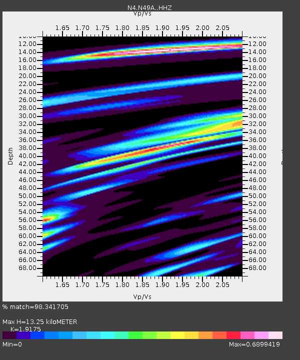
| Estimated Moho Depth: |
13.25 km |
| Estimated Crust Vp/Vs: |
1.92 |
| Assumed Crust Vp: |
6.498 km/s |
| Estimated Crust Vs: |
3.389 km/s |
| Estimated Crust Poisson's Ratio: |
0.31 |
|
| Radial Match: |
98.341705 % |
| Radial Bump: |
214 |
| Transverse Match: |
89.99589 % |
| Transverse Bump: |
400 |
| SOD ConfigId: |
7422571 |
| Insert Time: |
2019-04-20 01:46:54.788 +0000 |
| GWidth: |
2.5 |
| Max Bumps: |
400 |
| Tol: |
0.001 |
|

Signal To Noise
| Channel | StoN | STA | LTA |
| N4:N49A: :HHZ:20150729T02:43:35.660004Z | 26.506208 | 1.6557641E-6 | 6.246703E-8 |
| N4:N49A: :HHN:20150729T02:43:35.660004Z | 17.332108 | 8.0880693E-7 | 4.6665235E-8 |
| N4:N49A: :HHE:20150729T02:43:35.660004Z | 12.165328 | 7.787541E-7 | 6.401423E-8 |
| Arrivals |
| Ps | 2.0 SECOND |
| PpPs | 5.6 SECOND |
| PsPs/PpSs | 7.6 SECOND |


