You are here: Home > Network List > N4 - Central and EAstern US Network Stations List
> Station N58A Sunbury, PA, USA > Earthquake Result Viewer
N58A Sunbury, PA, USA - Earthquake Result Viewer
| Earthquake location: |
Southern Alaska |
| Earthquake latitude/longitude: |
59.9/-153.1 |
| Earthquake time(UTC): |
2015/07/29 (210) 02:35:58 GMT |
| Earthquake Depth: |
118 km |
| Earthquake Magnitude: |
6.3 ML, 6.2 MWP, 6.2 MI, 6.3 MWW |
| Earthquake Catalog/Contributor: |
NEIC PDE/NEIC COMCAT |
|
| Network: |
N4 Central and EAstern US Network |
| Station: |
N58A Sunbury, PA, USA |
| Lat/Lon: |
40.84 N/76.72 W |
| Elevation: |
200 m |
|
| Distance: |
49.2 deg |
| Az: |
76.736 deg |
| Baz: |
319.709 deg |
| Ray Param: |
0.06843284 |
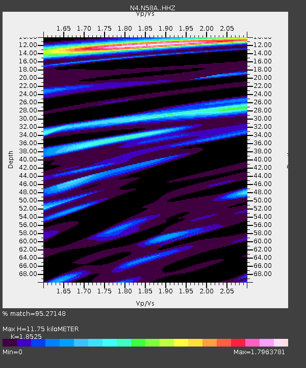
| Estimated Moho Depth: |
11.75 km |
| Estimated Crust Vp/Vs: |
1.85 |
| Assumed Crust Vp: |
6.121 km/s |
| Estimated Crust Vs: |
3.304 km/s |
| Estimated Crust Poisson's Ratio: |
0.29 |
|
| Radial Match: |
95.27148 % |
| Radial Bump: |
394 |
| Transverse Match: |
94.8262 % |
| Transverse Bump: |
400 |
| SOD ConfigId: |
7422571 |
| Insert Time: |
2019-04-20 01:46:59.270 +0000 |
| GWidth: |
2.5 |
| Max Bumps: |
400 |
| Tol: |
0.001 |
|

Signal To Noise
| Channel | StoN | STA | LTA |
| N4:N58A: :HHZ:20150729T02:44:04.619995Z | 28.736315 | 2.1241667E-6 | 7.3919246E-8 |
| N4:N58A: :HHN:20150729T02:44:04.619995Z | 10.107152 | 6.8445473E-7 | 6.771984E-8 |
| N4:N58A: :HHE:20150729T02:44:04.619995Z | 7.798402 | 5.926715E-7 | 7.599909E-8 |
| Arrivals |
| Ps | 1.7 SECOND |
| PpPs | 5.2 SECOND |
| PsPs/PpSs | 6.9 SECOND |


