You are here: Home > Network List > N4 - Central and EAstern US Network Stations List
> Station X58A Rowland, NC, USA > Earthquake Result Viewer
X58A Rowland, NC, USA - Earthquake Result Viewer
| Earthquake location: |
Southern Alaska |
| Earthquake latitude/longitude: |
59.9/-153.1 |
| Earthquake time(UTC): |
2015/07/29 (210) 02:35:58 GMT |
| Earthquake Depth: |
118 km |
| Earthquake Magnitude: |
6.3 ML, 6.2 MWP, 6.2 MI, 6.3 MWW |
| Earthquake Catalog/Contributor: |
NEIC PDE/NEIC COMCAT |
|
| Network: |
N4 Central and EAstern US Network |
| Station: |
X58A Rowland, NC, USA |
| Lat/Lon: |
34.55 N/79.34 W |
| Elevation: |
45 m |
|
| Distance: |
52.8 deg |
| Az: |
83.881 deg |
| Baz: |
322.608 deg |
| Ray Param: |
0.06611479 |
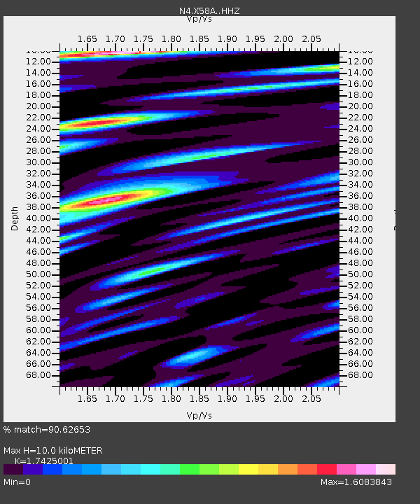
| Estimated Moho Depth: |
10.0 km |
| Estimated Crust Vp/Vs: |
1.74 |
| Assumed Crust Vp: |
6.565 km/s |
| Estimated Crust Vs: |
3.767 km/s |
| Estimated Crust Poisson's Ratio: |
0.25 |
|
| Radial Match: |
90.62653 % |
| Radial Bump: |
400 |
| Transverse Match: |
79.73438 % |
| Transverse Bump: |
400 |
| SOD ConfigId: |
7422571 |
| Insert Time: |
2019-04-20 01:47:45.810 +0000 |
| GWidth: |
2.5 |
| Max Bumps: |
400 |
| Tol: |
0.001 |
|

Signal To Noise
| Channel | StoN | STA | LTA |
| N4:X58A: :HHZ:20150729T02:44:31.429993Z | 4.3445473 | 6.940169E-7 | 1.5974435E-7 |
| N4:X58A: :HHN:20150729T02:44:31.429993Z | 2.4961002 | 3.4408134E-7 | 1.3784758E-7 |
| N4:X58A: :HHE:20150729T02:44:31.429993Z | 1.9694829 | 3.8546239E-7 | 1.9571756E-7 |
| Arrivals |
| Ps | 1.2 SECOND |
| PpPs | 3.9 SECOND |
| PsPs/PpSs | 5.1 SECOND |


