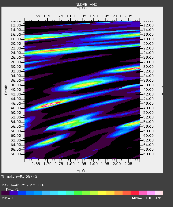
DRE Drenchia - Earthquake Result Viewer

Earthquake location: Southern Alaska
Earthquake latitude/longitude: 59.9/-153.1
Earthquake time(UTC): 2015/07/29 (210) 02:35:58 GMT
Earthquake Depth: 118 km
Earthquake Magnitude: 6.3 ML, 6.2 MWP, 6.2 MI, 6.3 MWW
Earthquake Catalog/Contributor: NEIC PDE/NEIC COMCAT
Network: NI North-East Italy Broadband Network
Station: DRE Drenchia
Lat/Lon: 46.17 N/13.65 E
Elevation: 810 m
Distance: 73.7 deg
Az: 9.574 deg
Baz: 353.07 deg
Ray Param: 0.052516047
Estimated Moho Depth: 46.25 km
Estimated Crust Vp/Vs: 1.71
Assumed Crust Vp: 6.35 km/s
Estimated Crust Vs: 3.713 km/s
Estimated Crust Poisson's Ratio: 0.24
Radial Match: 91.08743 %
Radial Bump: 400
Transverse Match: 84.23767 %
Transverse Bump: 400
SOD ConfigId: 7422571
Insert Time: 2019-04-20 01:48:05.573 +0000
GWidth: 2.5
Max Bumps: 400
Tol: 0.001

Signal To Noise

ChannelStoNSTALTA
NI:DRE: :HHZ:20150729T02:46:47.65802Z13.9548286.9531984E-74.982647E-8
NI:DRE: :HHN:20150729T02:46:47.65802Z10.0379613.2368507E-73.22461E-8
NI:DRE: :HHE:20150729T02:46:47.65802Z4.21539641.8476281E-74.383047E-8
Arrivals
Ps5.3 SECOND
PpPs19 SECOND
PsPs/PpSs24 SECOND