You are here: Home > Network List > PO - Portable Observatories for Lithospheric Analysis and Research Investigating Seis Stations List
> Station MATQ Matagami, QC > Earthquake Result Viewer
MATQ Matagami, QC - Earthquake Result Viewer
| Earthquake location: |
Southern Alaska |
| Earthquake latitude/longitude: |
59.9/-153.1 |
| Earthquake time(UTC): |
2015/07/29 (210) 02:35:58 GMT |
| Earthquake Depth: |
118 km |
| Earthquake Magnitude: |
6.3 ML, 6.2 MWP, 6.2 MI, 6.3 MWW |
| Earthquake Catalog/Contributor: |
NEIC PDE/NEIC COMCAT |
|
| Network: |
PO Portable Observatories for Lithospheric Analysis and Research Investigating Seis |
| Station: |
MATQ Matagami, QC |
| Lat/Lon: |
49.76 N/77.64 W |
| Elevation: |
280 m |
|
| Distance: |
42.3 deg |
| Az: |
68.85 deg |
| Baz: |
313.539 deg |
| Ray Param: |
0.07284935 |
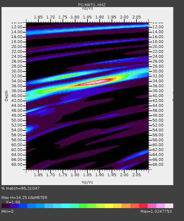
| Estimated Moho Depth: |
34.25 km |
| Estimated Crust Vp/Vs: |
1.88 |
| Assumed Crust Vp: |
6.61 km/s |
| Estimated Crust Vs: |
3.516 km/s |
| Estimated Crust Poisson's Ratio: |
0.30 |
|
| Radial Match: |
95.31047 % |
| Radial Bump: |
215 |
| Transverse Match: |
78.96777 % |
| Transverse Bump: |
400 |
| SOD ConfigId: |
7422571 |
| Insert Time: |
2019-04-20 01:49:22.933 +0000 |
| GWidth: |
2.5 |
| Max Bumps: |
400 |
| Tol: |
0.001 |
|

Signal To Noise
| Channel | StoN | STA | LTA |
| PO:MATQ: :HHZ:20150729T02:43:10.119995Z | 37.92049 | 2.5356487E-6 | 6.686751E-8 |
| PO:MATQ: :HHN:20150729T02:43:10.119995Z | 12.096041 | 8.3436066E-7 | 6.8978E-8 |
| PO:MATQ: :HHE:20150729T02:43:10.119995Z | 25.404057 | 1.2532886E-6 | 4.933419E-8 |
| Arrivals |
| Ps | 4.9 SECOND |
| PpPs | 14 SECOND |
| PsPs/PpSs | 19 SECOND |


