You are here: Home > Network List > TA - USArray Transportable Network (new EarthScope stations) Stations List
> Station G63A Kingsbury, ME, USA > Earthquake Result Viewer
G63A Kingsbury, ME, USA - Earthquake Result Viewer
| Earthquake location: |
Southern Alaska |
| Earthquake latitude/longitude: |
59.9/-153.1 |
| Earthquake time(UTC): |
2015/07/29 (210) 02:35:58 GMT |
| Earthquake Depth: |
118 km |
| Earthquake Magnitude: |
6.3 ML, 6.2 MWP, 6.2 MI, 6.3 MWW |
| Earthquake Catalog/Contributor: |
NEIC PDE/NEIC COMCAT |
|
| Network: |
TA USArray Transportable Network (new EarthScope stations) |
| Station: |
G63A Kingsbury, ME, USA |
| Lat/Lon: |
45.11 N/69.62 W |
| Elevation: |
363 m |
|
| Distance: |
49.4 deg |
| Az: |
67.859 deg |
| Baz: |
318.745 deg |
| Ray Param: |
0.068325065 |
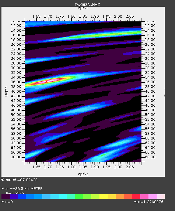
| Estimated Moho Depth: |
35.5 km |
| Estimated Crust Vp/Vs: |
1.69 |
| Assumed Crust Vp: |
6.419 km/s |
| Estimated Crust Vs: |
3.793 km/s |
| Estimated Crust Poisson's Ratio: |
0.23 |
|
| Radial Match: |
87.82428 % |
| Radial Bump: |
267 |
| Transverse Match: |
85.536606 % |
| Transverse Bump: |
399 |
| SOD ConfigId: |
7422571 |
| Insert Time: |
2019-04-20 01:50:03.568 +0000 |
| GWidth: |
2.5 |
| Max Bumps: |
400 |
| Tol: |
0.001 |
|

Signal To Noise
| Channel | StoN | STA | LTA |
| TA:G63A: :HHZ:20150729T02:44:05.790009Z | 14.153551 | 1.365444E-6 | 9.647359E-8 |
| TA:G63A: :HHN:20150729T02:44:05.790009Z | 5.3416615 | 5.363185E-7 | 1.00402936E-7 |
| TA:G63A: :HHE:20150729T02:44:05.790009Z | 5.7699585 | 3.5048825E-7 | 6.074364E-8 |
| Arrivals |
| Ps | 4.1 SECOND |
| PpPs | 14 SECOND |
| PsPs/PpSs | 18 SECOND |


