You are here: Home > Network List > TA - USArray Transportable Network (new EarthScope stations) Stations List
> Station G65A Princeton, ME, USA > Earthquake Result Viewer
G65A Princeton, ME, USA - Earthquake Result Viewer
| Earthquake location: |
Southern Alaska |
| Earthquake latitude/longitude: |
59.9/-153.1 |
| Earthquake time(UTC): |
2015/07/29 (210) 02:35:58 GMT |
| Earthquake Depth: |
118 km |
| Earthquake Magnitude: |
6.3 ML, 6.2 MWP, 6.2 MI, 6.3 MWW |
| Earthquake Catalog/Contributor: |
NEIC PDE/NEIC COMCAT |
|
| Network: |
TA USArray Transportable Network (new EarthScope stations) |
| Station: |
G65A Princeton, ME, USA |
| Lat/Lon: |
45.20 N/67.56 W |
| Elevation: |
78 m |
|
| Distance: |
50.3 deg |
| Az: |
66.35 deg |
| Baz: |
319.225 deg |
| Ray Param: |
0.067743264 |
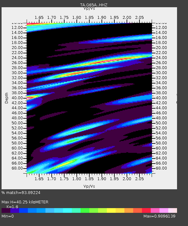
| Estimated Moho Depth: |
40.25 km |
| Estimated Crust Vp/Vs: |
1.60 |
| Assumed Crust Vp: |
6.419 km/s |
| Estimated Crust Vs: |
4.012 km/s |
| Estimated Crust Poisson's Ratio: |
0.18 |
|
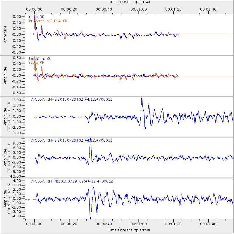
| Radial Match: |
93.89224 % |
| Radial Bump: |
351 |
| Transverse Match: |
84.05391 % |
| Transverse Bump: |
400 |
| SOD ConfigId: |
7422571 |
| Insert Time: |
2019-04-20 01:50:05.229 +0000 |
| GWidth: |
2.5 |
| Max Bumps: |
400 |
| Tol: |
0.001 |
|
Signal To Noise
| Channel | StoN | STA | LTA |
| TA:G65A: :HHZ:20150729T02:44:12.470001Z | 13.737567 | 1.4274054E-6 | 1.0390526E-7 |
| TA:G65A: :HHN:20150729T02:44:12.470001Z | 5.8693857 | 5.203131E-7 | 8.864865E-8 |
| TA:G65A: :HHE:20150729T02:44:12.470001Z | 5.638369 | 4.150136E-7 | 7.360526E-8 |
| Arrivals |
| Ps | 4.0 SECOND |
| PpPs | 15 SECOND |
| PsPs/PpSs | 19 SECOND |


