You are here: Home > Network List > TA - USArray Transportable Network (new EarthScope stations) Stations List
> Station I57A Carthage, NY, USA > Earthquake Result Viewer
I57A Carthage, NY, USA - Earthquake Result Viewer
| Earthquake location: |
Southern Alaska |
| Earthquake latitude/longitude: |
59.9/-153.1 |
| Earthquake time(UTC): |
2015/07/29 (210) 02:35:58 GMT |
| Earthquake Depth: |
118 km |
| Earthquake Magnitude: |
6.3 ML, 6.2 MWP, 6.2 MI, 6.3 MWW |
| Earthquake Catalog/Contributor: |
NEIC PDE/NEIC COMCAT |
|
| Network: |
TA USArray Transportable Network (new EarthScope stations) |
| Station: |
I57A Carthage, NY, USA |
| Lat/Lon: |
43.94 N/75.66 W |
| Elevation: |
321 m |
|
| Distance: |
47.4 deg |
| Az: |
73.222 deg |
| Baz: |
318.082 deg |
| Ray Param: |
0.069602184 |
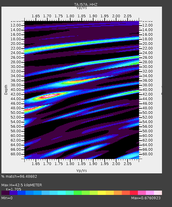
| Estimated Moho Depth: |
42.5 km |
| Estimated Crust Vp/Vs: |
1.71 |
| Assumed Crust Vp: |
6.419 km/s |
| Estimated Crust Vs: |
3.765 km/s |
| Estimated Crust Poisson's Ratio: |
0.24 |
|
| Radial Match: |
96.48682 % |
| Radial Bump: |
316 |
| Transverse Match: |
85.12422 % |
| Transverse Bump: |
400 |
| SOD ConfigId: |
7422571 |
| Insert Time: |
2019-04-20 01:50:13.122 +0000 |
| GWidth: |
2.5 |
| Max Bumps: |
400 |
| Tol: |
0.001 |
|

Signal To Noise
| Channel | StoN | STA | LTA |
| TA:I57A: :HHZ:20150729T02:43:50.660004Z | 25.04098 | 1.4260992E-6 | 5.695061E-8 |
| TA:I57A: :HHN:20150729T02:43:50.660004Z | 12.031977 | 5.695163E-7 | 4.733356E-8 |
| TA:I57A: :HHE:20150729T02:43:50.660004Z | 10.334176 | 4.6172215E-7 | 4.4679147E-8 |
| Arrivals |
| Ps | 5.0 SECOND |
| PpPs | 17 SECOND |
| PsPs/PpSs | 22 SECOND |


