You are here: Home > Network List > TA - USArray Transportable Network (new EarthScope stations) Stations List
> Station J58A Remsen, NY, USA > Earthquake Result Viewer
J58A Remsen, NY, USA - Earthquake Result Viewer
| Earthquake location: |
Southern Alaska |
| Earthquake latitude/longitude: |
59.9/-153.1 |
| Earthquake time(UTC): |
2015/07/29 (210) 02:35:58 GMT |
| Earthquake Depth: |
118 km |
| Earthquake Magnitude: |
6.3 ML, 6.2 MWP, 6.2 MI, 6.3 MWW |
| Earthquake Catalog/Contributor: |
NEIC PDE/NEIC COMCAT |
|
| Network: |
TA USArray Transportable Network (new EarthScope stations) |
| Station: |
J58A Remsen, NY, USA |
| Lat/Lon: |
43.36 N/75.29 W |
| Elevation: |
436 m |
|
| Distance: |
48.0 deg |
| Az: |
73.467 deg |
| Baz: |
318.504 deg |
| Ray Param: |
0.06921286 |
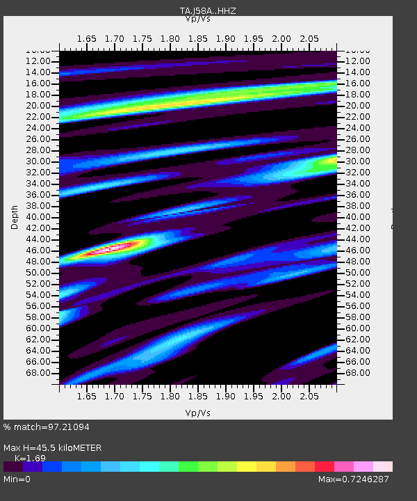
| Estimated Moho Depth: |
45.5 km |
| Estimated Crust Vp/Vs: |
1.69 |
| Assumed Crust Vp: |
6.419 km/s |
| Estimated Crust Vs: |
3.798 km/s |
| Estimated Crust Poisson's Ratio: |
0.23 |
|
| Radial Match: |
97.21094 % |
| Radial Bump: |
273 |
| Transverse Match: |
85.31346 % |
| Transverse Bump: |
400 |
| SOD ConfigId: |
7422571 |
| Insert Time: |
2019-04-20 01:50:17.568 +0000 |
| GWidth: |
2.5 |
| Max Bumps: |
400 |
| Tol: |
0.001 |
|

Signal To Noise
| Channel | StoN | STA | LTA |
| TA:J58A: :HHZ:20150729T02:43:55.369995Z | 24.465517 | 1.7171357E-6 | 7.0185955E-8 |
| TA:J58A: :HHN:20150729T02:43:55.369995Z | 12.616155 | 7.8562806E-7 | 6.2271596E-8 |
| TA:J58A: :HHE:20150729T02:43:55.369995Z | 11.48967 | 6.126626E-7 | 5.3322903E-8 |
| Arrivals |
| Ps | 5.2 SECOND |
| PpPs | 18 SECOND |
| PsPs/PpSs | 23 SECOND |


