You are here: Home > Network List > TA - USArray Transportable Network (new EarthScope stations) Stations List
> Station K22A Casper, WY, USA > Earthquake Result Viewer
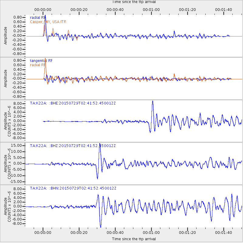
K22A Casper, WY, USA - Earthquake Result Viewer
*The percent match for this event was below the threshold and hence no stack was calculated.
| Earthquake location: |
Southern Alaska |
| Earthquake latitude/longitude: |
59.9/-153.1 |
| Earthquake time(UTC): |
2015/07/29 (210) 02:35:58 GMT |
| Earthquake Depth: |
118 km |
| Earthquake Magnitude: |
6.3 ML, 6.2 MWP, 6.2 MI, 6.3 MWW |
| Earthquake Catalog/Contributor: |
NEIC PDE/NEIC COMCAT |
|
| Network: |
TA USArray Transportable Network (new EarthScope stations) |
| Station: |
K22A Casper, WY, USA |
| Lat/Lon: |
42.65 N/106.52 W |
| Elevation: |
1686 m |
|
| Distance: |
33.0 deg |
| Az: |
100.362 deg |
| Baz: |
317.77 deg |
| Ray Param: |
$rayparam |
*The percent match for this event was below the threshold and hence was not used in the summary stack. |
|
| Radial Match: |
93.26577 % |
| Radial Bump: |
400 |
| Transverse Match: |
86.34325 % |
| Transverse Bump: |
400 |
| SOD ConfigId: |
7422571 |
| Insert Time: |
2019-04-20 01:50:22.622 +0000 |
| GWidth: |
2.5 |
| Max Bumps: |
400 |
| Tol: |
0.001 |
|
Signal To Noise
| Channel | StoN | STA | LTA |
| TA:K22A: :BHZ:20150729T02:41:52.450012Z | 6.07729 | 5.467933E-7 | 8.997321E-8 |
| TA:K22A: :BHN:20150729T02:41:52.450012Z | 3.3126583 | 2.0024267E-7 | 6.0447725E-8 |
| TA:K22A: :BHE:20150729T02:41:52.450012Z | 3.0390875 | 1.830529E-7 | 6.023285E-8 |
| Arrivals |
| Ps | |
| PpPs | |
| PsPs/PpSs | |


