You are here: Home > Network List > TA - USArray Transportable Network (new EarthScope stations) Stations List
> Station M65A Busby, Falmouth, MA, USA > Earthquake Result Viewer
M65A Busby, Falmouth, MA, USA - Earthquake Result Viewer
| Earthquake location: |
Southern Alaska |
| Earthquake latitude/longitude: |
59.9/-153.1 |
| Earthquake time(UTC): |
2015/07/29 (210) 02:35:58 GMT |
| Earthquake Depth: |
118 km |
| Earthquake Magnitude: |
6.3 ML, 6.2 MWP, 6.2 MI, 6.3 MWW |
| Earthquake Catalog/Contributor: |
NEIC PDE/NEIC COMCAT |
|
| Network: |
TA USArray Transportable Network (new EarthScope stations) |
| Station: |
M65A Busby, Falmouth, MA, USA |
| Lat/Lon: |
41.56 N/70.65 W |
| Elevation: |
22 m |
|
| Distance: |
51.6 deg |
| Az: |
71.582 deg |
| Baz: |
320.409 deg |
| Ray Param: |
0.06689352 |
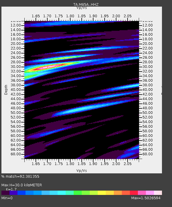
| Estimated Moho Depth: |
30.0 km |
| Estimated Crust Vp/Vs: |
1.70 |
| Assumed Crust Vp: |
6.472 km/s |
| Estimated Crust Vs: |
3.807 km/s |
| Estimated Crust Poisson's Ratio: |
0.24 |
|
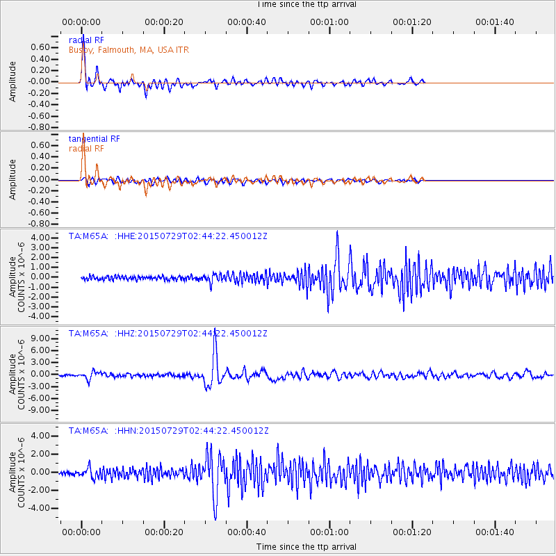
| Radial Match: |
92.381355 % |
| Radial Bump: |
400 |
| Transverse Match: |
68.39424 % |
| Transverse Bump: |
400 |
| SOD ConfigId: |
7422571 |
| Insert Time: |
2019-04-20 01:50:32.562 +0000 |
| GWidth: |
2.5 |
| Max Bumps: |
400 |
| Tol: |
0.001 |
|
Signal To Noise
| Channel | StoN | STA | LTA |
| TA:M65A: :HHZ:20150729T02:44:22.450012Z | 6.6088533 | 9.409243E-7 | 1.4237331E-7 |
| TA:M65A: :HHN:20150729T02:44:22.450012Z | 3.0103836 | 5.4613673E-7 | 1.8141765E-7 |
| TA:M65A: :HHE:20150729T02:44:22.450012Z | 2.3442144 | 4.075146E-7 | 1.7383844E-7 |
| Arrivals |
| Ps | 3.4 SECOND |
| PpPs | 12 SECOND |
| PsPs/PpSs | 15 SECOND |


