You are here: Home > Network List > TA - USArray Transportable Network (new EarthScope stations) Stations List
> Station N59A State Game Land 141, Hazleton, PA, USA > Earthquake Result Viewer
N59A State Game Land 141, Hazleton, PA, USA - Earthquake Result Viewer
| Earthquake location: |
Southern Alaska |
| Earthquake latitude/longitude: |
59.9/-153.1 |
| Earthquake time(UTC): |
2015/07/29 (210) 02:35:58 GMT |
| Earthquake Depth: |
118 km |
| Earthquake Magnitude: |
6.3 ML, 6.2 MWP, 6.2 MI, 6.3 MWW |
| Earthquake Catalog/Contributor: |
NEIC PDE/NEIC COMCAT |
|
| Network: |
TA USArray Transportable Network (new EarthScope stations) |
| Station: |
N59A State Game Land 141, Hazleton, PA, USA |
| Lat/Lon: |
40.92 N/75.77 W |
| Elevation: |
508 m |
|
| Distance: |
49.6 deg |
| Az: |
75.95 deg |
| Baz: |
319.815 deg |
| Ray Param: |
0.06817671 |
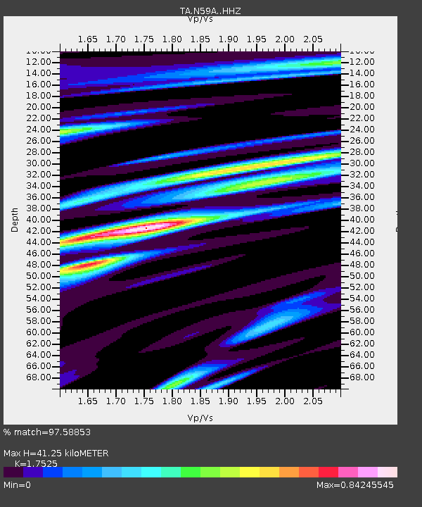
| Estimated Moho Depth: |
41.25 km |
| Estimated Crust Vp/Vs: |
1.75 |
| Assumed Crust Vp: |
6.283 km/s |
| Estimated Crust Vs: |
3.585 km/s |
| Estimated Crust Poisson's Ratio: |
0.26 |
|
| Radial Match: |
97.58853 % |
| Radial Bump: |
351 |
| Transverse Match: |
93.93645 % |
| Transverse Bump: |
400 |
| SOD ConfigId: |
7422571 |
| Insert Time: |
2019-04-20 01:50:38.676 +0000 |
| GWidth: |
2.5 |
| Max Bumps: |
400 |
| Tol: |
0.001 |
|
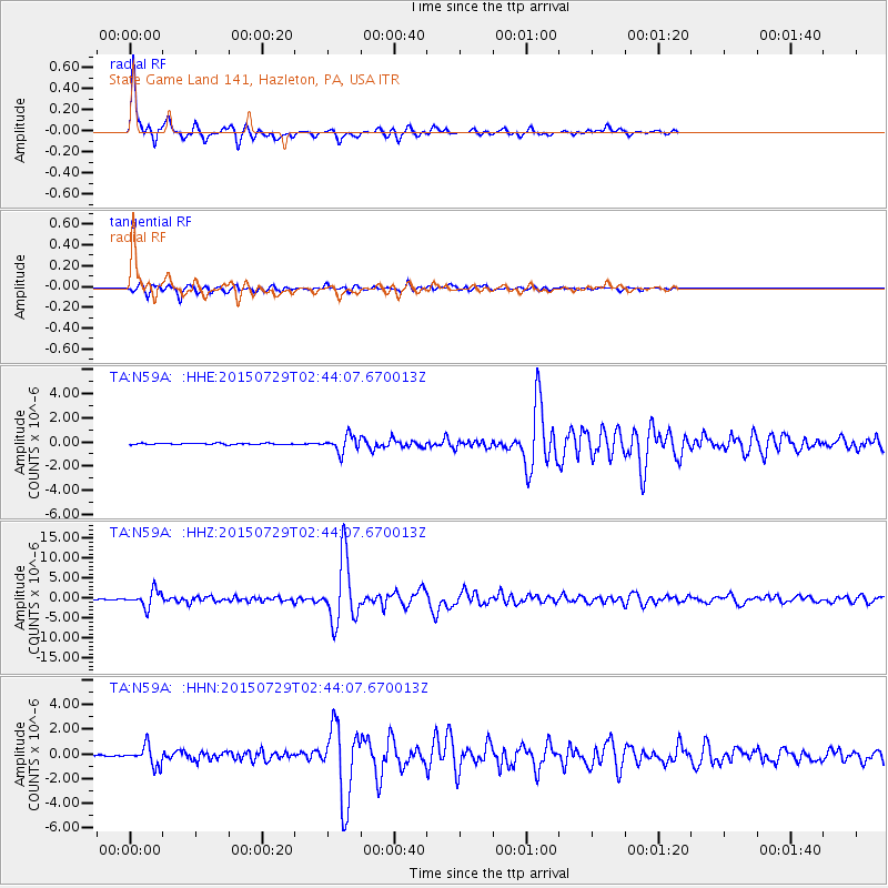
Signal To Noise
| Channel | StoN | STA | LTA |
| TA:N59A: :HHZ:20150729T02:44:07.670013Z | 18.120481 | 2.042941E-6 | 1.1274209E-7 |
| TA:N59A: :HHN:20150729T02:44:07.670013Z | 12.833854 | 7.901341E-7 | 6.1566396E-8 |
| TA:N59A: :HHE:20150729T02:44:07.670013Z | 12.8918915 | 6.6956795E-7 | 5.1937135E-8 |
| Arrivals |
| Ps | 5.2 SECOND |
| PpPs | 17 SECOND |
| PsPs/PpSs | 22 SECOND |


