You are here: Home > Network List > TA - USArray Transportable Network (new EarthScope stations) Stations List
> Station P60A Greenville, DE, USA > Earthquake Result Viewer
P60A Greenville, DE, USA - Earthquake Result Viewer
| Earthquake location: |
Southern Alaska |
| Earthquake latitude/longitude: |
59.9/-153.1 |
| Earthquake time(UTC): |
2015/07/29 (210) 02:35:58 GMT |
| Earthquake Depth: |
118 km |
| Earthquake Magnitude: |
6.3 ML, 6.2 MWP, 6.2 MI, 6.3 MWW |
| Earthquake Catalog/Contributor: |
NEIC PDE/NEIC COMCAT |
|
| Network: |
TA USArray Transportable Network (new EarthScope stations) |
| Station: |
P60A Greenville, DE, USA |
| Lat/Lon: |
39.81 N/75.64 W |
| Elevation: |
105 m |
|
| Distance: |
50.6 deg |
| Az: |
76.77 deg |
| Baz: |
320.428 deg |
| Ray Param: |
0.067584395 |
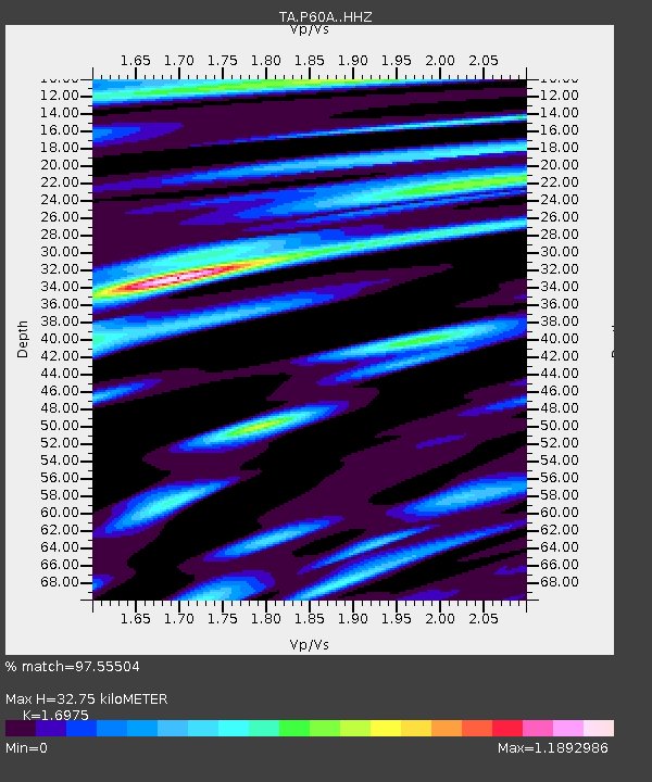
| Estimated Moho Depth: |
32.75 km |
| Estimated Crust Vp/Vs: |
1.70 |
| Assumed Crust Vp: |
6.287 km/s |
| Estimated Crust Vs: |
3.704 km/s |
| Estimated Crust Poisson's Ratio: |
0.23 |
|
| Radial Match: |
97.55504 % |
| Radial Bump: |
397 |
| Transverse Match: |
87.92418 % |
| Transverse Bump: |
400 |
| SOD ConfigId: |
7422571 |
| Insert Time: |
2019-04-20 01:50:42.850 +0000 |
| GWidth: |
2.5 |
| Max Bumps: |
400 |
| Tol: |
0.001 |
|

Signal To Noise
| Channel | StoN | STA | LTA |
| TA:P60A: :HHZ:20150729T02:44:14.549988Z | 19.717722 | 1.410013E-6 | 7.150994E-8 |
| TA:P60A: :HHN:20150729T02:44:14.549988Z | 8.322056 | 4.5950873E-7 | 5.5215775E-8 |
| TA:P60A: :HHE:20150729T02:44:14.549988Z | 5.234188 | 3.3613014E-7 | 6.42182E-8 |
| Arrivals |
| Ps | 3.8 SECOND |
| PpPs | 13 SECOND |
| PsPs/PpSs | 17 SECOND |


