You are here: Home > Network List > UU - University of Utah Regional Network Stations List
> Station LCMT Little Creek Mountain, UT, USA > Earthquake Result Viewer
LCMT Little Creek Mountain, UT, USA - Earthquake Result Viewer

| Earthquake location: |
Southern Alaska |
| Earthquake latitude/longitude: |
59.9/-153.1 |
| Earthquake time(UTC): |
2015/07/29 (210) 02:35:58 GMT |
| Earthquake Depth: |
118 km |
| Earthquake Magnitude: |
6.3 ML, 6.2 MWP, 6.2 MI, 6.3 MWW |
| Earthquake Catalog/Contributor: |
NEIC PDE/NEIC COMCAT |
|
| Network: |
UU University of Utah Regional Network |
| Station: |
LCMT Little Creek Mountain, UT, USA |
| Lat/Lon: |
37.01 N/113.24 W |
| Elevation: |
1411 m |
|
| Distance: |
34.2 deg |
| Az: |
114.047 deg |
| Baz: |
324.894 deg |
| Ray Param: |
0.077506766 |
| Estimated Moho Depth: |
14.5 km |
| Estimated Crust Vp/Vs: |
2.08 |
| Assumed Crust Vp: |
6.194 km/s |
| Estimated Crust Vs: |
2.978 km/s |
| Estimated Crust Poisson's Ratio: |
0.35 |
|
| Radial Match: |
95.214905 % |
| Radial Bump: |
259 |
| Transverse Match: |
87.06781 % |
| Transverse Bump: |
400 |
| SOD ConfigId: |
7422571 |
| Insert Time: |
2019-04-20 01:51:31.681 +0000 |
| GWidth: |
2.5 |
| Max Bumps: |
400 |
| Tol: |
0.001 |
|
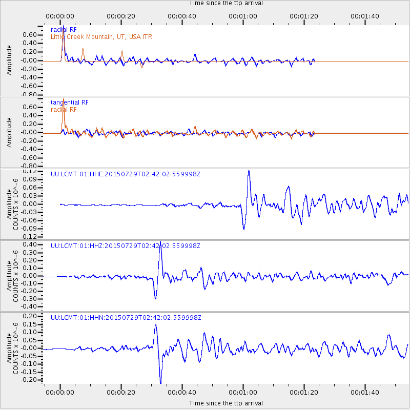
Signal To Noise
| Channel | StoN | STA | LTA |
| UU:LCMT:01:HHZ:20150729T02:42:02.559998Z | 1.7159153 | 3.586715E-9 | 2.0902633E-9 |
| UU:LCMT:01:HHN:20150729T02:42:02.559998Z | 1.5148512 | 2.5370597E-9 | 1.6747914E-9 |
| UU:LCMT:01:HHE:20150729T02:42:02.559998Z | 1.2701677 | 1.7883058E-9 | 1.407929E-9 |
| Arrivals |
| Ps | 2.7 SECOND |
| PpPs | 6.8 SECOND |
| PsPs/PpSs | 9.5 SECOND |


