You are here: Home > Network List > X812 - Deep Structure of Three Continental Sutures in Eastern North America Stations List
> Station QM16 Land Trust North, Maine, USA > Earthquake Result Viewer
QM16 Land Trust North, Maine, USA - Earthquake Result Viewer
| Earthquake location: |
Southern Alaska |
| Earthquake latitude/longitude: |
59.9/-153.1 |
| Earthquake time(UTC): |
2015/07/29 (210) 02:35:58 GMT |
| Earthquake Depth: |
118 km |
| Earthquake Magnitude: |
6.3 ML, 6.2 MWP, 6.2 MI, 6.3 MWW |
| Earthquake Catalog/Contributor: |
NEIC PDE/NEIC COMCAT |
|
| Network: |
X8 Deep Structure of Three Continental Sutures in Eastern North America |
| Station: |
QM16 Land Trust North, Maine, USA |
| Lat/Lon: |
45.21 N/67.95 W |
| Elevation: |
126 m |
|
| Distance: |
50.1 deg |
| Az: |
66.613 deg |
| Baz: |
319.119 deg |
| Ray Param: |
0.06786208 |
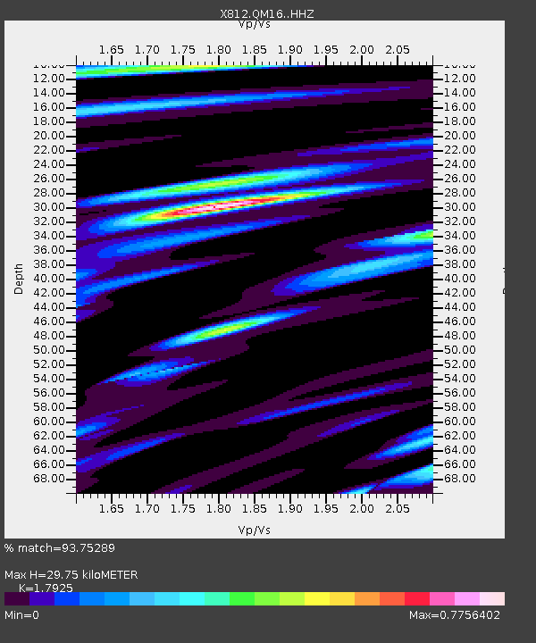
| Estimated Moho Depth: |
29.75 km |
| Estimated Crust Vp/Vs: |
1.79 |
| Assumed Crust Vp: |
6.419 km/s |
| Estimated Crust Vs: |
3.581 km/s |
| Estimated Crust Poisson's Ratio: |
0.27 |
|
| Radial Match: |
93.75289 % |
| Radial Bump: |
400 |
| Transverse Match: |
81.89051 % |
| Transverse Bump: |
400 |
| SOD ConfigId: |
7422571 |
| Insert Time: |
2019-04-20 01:52:08.921 +0000 |
| GWidth: |
2.5 |
| Max Bumps: |
400 |
| Tol: |
0.001 |
|

Signal To Noise
| Channel | StoN | STA | LTA |
| X8:QM16: :HHZ:20150729T02:44:11.075012Z | 14.924644 | 1.3906078E-6 | 9.3175274E-8 |
| X8:QM16: :HHN:20150729T02:44:11.075012Z | 6.2632804 | 6.1018E-7 | 9.742179E-8 |
| X8:QM16: :HHE:20150729T02:44:11.075012Z | 5.207376 | 4.296278E-7 | 8.2503696E-8 |
| Arrivals |
| Ps | 3.9 SECOND |
| PpPs | 12 SECOND |
| PsPs/PpSs | 16 SECOND |


