You are here: Home > Network List > X812 - Deep Structure of Three Continental Sutures in Eastern North America Stations List
> Station QM34 Ferme Vifranc, St-Pamphile, Quebec, Canada > Earthquake Result Viewer
QM34 Ferme Vifranc, St-Pamphile, Quebec, Canada - Earthquake Result Viewer
| Earthquake location: |
Southern Alaska |
| Earthquake latitude/longitude: |
59.9/-153.1 |
| Earthquake time(UTC): |
2015/07/29 (210) 02:35:58 GMT |
| Earthquake Depth: |
118 km |
| Earthquake Magnitude: |
6.3 ML, 6.2 MWP, 6.2 MI, 6.3 MWW |
| Earthquake Catalog/Contributor: |
NEIC PDE/NEIC COMCAT |
|
| Network: |
X8 Deep Structure of Three Continental Sutures in Eastern North America |
| Station: |
QM34 Ferme Vifranc, St-Pamphile, Quebec, Canada |
| Lat/Lon: |
47.02 N/69.83 W |
| Elevation: |
374 m |
|
| Distance: |
47.9 deg |
| Az: |
66.312 deg |
| Baz: |
317.57 deg |
| Ray Param: |
0.06930654 |
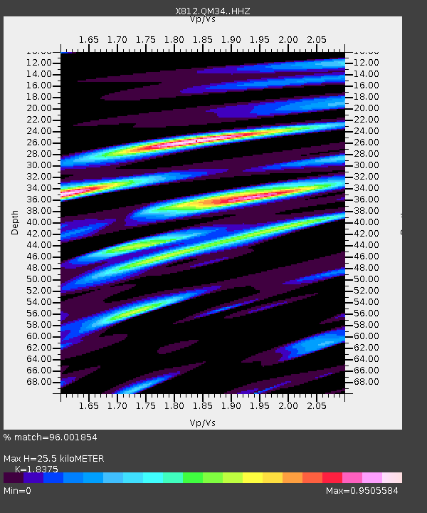
| Estimated Moho Depth: |
25.5 km |
| Estimated Crust Vp/Vs: |
1.84 |
| Assumed Crust Vp: |
6.419 km/s |
| Estimated Crust Vs: |
3.493 km/s |
| Estimated Crust Poisson's Ratio: |
0.29 |
|
| Radial Match: |
96.001854 % |
| Radial Bump: |
334 |
| Transverse Match: |
88.058784 % |
| Transverse Bump: |
400 |
| SOD ConfigId: |
7422571 |
| Insert Time: |
2019-04-20 01:52:10.178 +0000 |
| GWidth: |
2.5 |
| Max Bumps: |
400 |
| Tol: |
0.001 |
|
Signal To Noise
| Channel | StoN | STA | LTA |
| X8:QM34: :HHZ:20150729T02:43:54.174988Z | 22.305374 | 1.9571678E-6 | 8.7744226E-8 |
| X8:QM34: :HHN:20150729T02:43:54.174988Z | 11.239726 | 9.4691075E-7 | 8.4246786E-8 |
| X8:QM34: :HHE:20150729T02:43:54.174988Z | 11.39522 | 8.711073E-7 | 7.644498E-8 |
| Arrivals |
| Ps | 3.5 SECOND |
| PpPs | 11 SECOND |
| PsPs/PpSs | 14 SECOND |


