You are here: Home > Network List > X812 - Deep Structure of Three Continental Sutures in Eastern North America Stations List
> Station QMHP Harpswell, Maine > Earthquake Result Viewer
QMHP Harpswell, Maine - Earthquake Result Viewer
| Earthquake location: |
Southern Alaska |
| Earthquake latitude/longitude: |
59.9/-153.1 |
| Earthquake time(UTC): |
2015/07/29 (210) 02:35:58 GMT |
| Earthquake Depth: |
118 km |
| Earthquake Magnitude: |
6.3 ML, 6.2 MWP, 6.2 MI, 6.3 MWW |
| Earthquake Catalog/Contributor: |
NEIC PDE/NEIC COMCAT |
|
| Network: |
X8 Deep Structure of Three Continental Sutures in Eastern North America |
| Station: |
QMHP Harpswell, Maine |
| Lat/Lon: |
43.75 N/70.01 W |
| Elevation: |
22 m |
|
| Distance: |
50.3 deg |
| Az: |
69.31 deg |
| Baz: |
319.407 deg |
| Ray Param: |
0.06776802 |
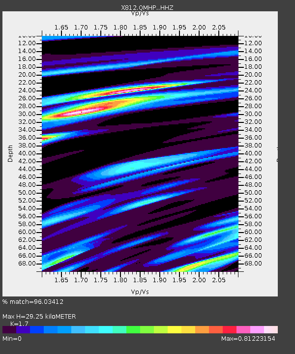
| Estimated Moho Depth: |
29.25 km |
| Estimated Crust Vp/Vs: |
1.70 |
| Assumed Crust Vp: |
6.419 km/s |
| Estimated Crust Vs: |
3.776 km/s |
| Estimated Crust Poisson's Ratio: |
0.24 |
|
| Radial Match: |
96.03412 % |
| Radial Bump: |
223 |
| Transverse Match: |
87.28274 % |
| Transverse Bump: |
392 |
| SOD ConfigId: |
7422571 |
| Insert Time: |
2019-04-20 01:52:11.167 +0000 |
| GWidth: |
2.5 |
| Max Bumps: |
400 |
| Tol: |
0.001 |
|

Signal To Noise
| Channel | StoN | STA | LTA |
| X8:QMHP: :HHZ:20150729T02:44:12.214996Z | 21.10709 | 1.7639895E-6 | 8.357332E-8 |
| X8:QMHP: :HHN:20150729T02:44:12.214996Z | 8.43572 | 7.2244205E-7 | 8.564082E-8 |
| X8:QMHP: :HHE:20150729T02:44:12.214996Z | 5.116236 | 5.770803E-7 | 1.1279391E-7 |
| Arrivals |
| Ps | 3.4 SECOND |
| PpPs | 12 SECOND |
| PsPs/PpSs | 15 SECOND |


