You are here: Home > Network List > XO11 - Ozark Illinois, Indiana and Kentucky ES Flexible Array Stations List
> Station KK48 KK48 of OIINK Flexarray > Earthquake Result Viewer
KK48 KK48 of OIINK Flexarray - Earthquake Result Viewer
| Earthquake location: |
Southern Alaska |
| Earthquake latitude/longitude: |
59.9/-153.1 |
| Earthquake time(UTC): |
2015/07/29 (210) 02:35:58 GMT |
| Earthquake Depth: |
118 km |
| Earthquake Magnitude: |
6.3 ML, 6.2 MWP, 6.2 MI, 6.3 MWW |
| Earthquake Catalog/Contributor: |
NEIC PDE/NEIC COMCAT |
|
| Network: |
XO Ozark Illinois, Indiana and Kentucky ES Flexible Array |
| Station: |
KK48 KK48 of OIINK Flexarray |
| Lat/Lon: |
36.87 N/84.94 W |
| Elevation: |
318 m |
|
| Distance: |
48.2 deg |
| Az: |
86.685 deg |
| Baz: |
321.133 deg |
| Ray Param: |
0.0691052 |
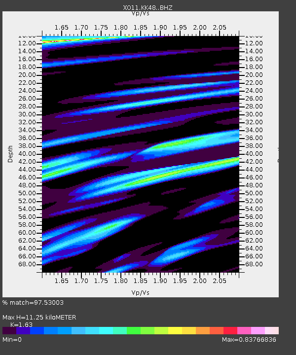
| Estimated Moho Depth: |
11.25 km |
| Estimated Crust Vp/Vs: |
1.63 |
| Assumed Crust Vp: |
6.476 km/s |
| Estimated Crust Vs: |
3.973 km/s |
| Estimated Crust Poisson's Ratio: |
0.20 |
|
| Radial Match: |
97.53003 % |
| Radial Bump: |
400 |
| Transverse Match: |
93.30546 % |
| Transverse Bump: |
400 |
| SOD ConfigId: |
7422571 |
| Insert Time: |
2019-04-20 01:52:50.530 +0000 |
| GWidth: |
2.5 |
| Max Bumps: |
400 |
| Tol: |
0.001 |
|

Signal To Noise
| Channel | StoN | STA | LTA |
| XO:KK48: :BHZ:20150729T02:43:56.795013Z | 8.329732 | 1.0996235E-6 | 1.3201188E-7 |
| XO:KK48: :BHN:20150729T02:43:56.795013Z | 8.2111025 | 4.6113027E-7 | 5.615936E-8 |
| XO:KK48: :BHE:20150729T02:43:56.795013Z | 3.4912806 | 3.1163614E-7 | 8.926126E-8 |
| Arrivals |
| Ps | 1.2 SECOND |
| PpPs | 4.3 SECOND |
| PsPs/PpSs | 5.4 SECOND |


