You are here: Home > Network List > US - United States National Seismic Network Stations List
> Station CBKS Cedar Bluff, Kansas, USA > Earthquake Result Viewer
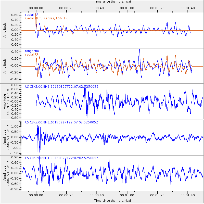
CBKS Cedar Bluff, Kansas, USA - Earthquake Result Viewer
*The percent match for this event was below the threshold and hence no stack was calculated.
| Earthquake location: |
Ecuador |
| Earthquake latitude/longitude: |
-1.2/-77.6 |
| Earthquake time(UTC): |
2015/03/27 (086) 21:59:39 GMT |
| Earthquake Depth: |
195 km |
| Earthquake Magnitude: |
5.5 MWW, 5.5 MWB |
| Earthquake Catalog/Contributor: |
NEIC PDE/NEIC COMCAT |
|
| Network: |
US United States National Seismic Network |
| Station: |
CBKS Cedar Bluff, Kansas, USA |
| Lat/Lon: |
38.81 N/99.74 W |
| Elevation: |
677 m |
|
| Distance: |
44.7 deg |
| Az: |
335.255 deg |
| Baz: |
147.61 deg |
| Ray Param: |
$rayparam |
*The percent match for this event was below the threshold and hence was not used in the summary stack. |
|
| Radial Match: |
49.097553 % |
| Radial Bump: |
400 |
| Transverse Match: |
52.764484 % |
| Transverse Bump: |
400 |
| SOD ConfigId: |
872571 |
| Insert Time: |
2015-04-12 06:12:20.809 +0000 |
| GWidth: |
2.5 |
| Max Bumps: |
400 |
| Tol: |
0.001 |
|
Signal To Noise
| Channel | StoN | STA | LTA |
| US:CBKS:00:BHZ:20150327T22:07:02.525005Z | 3.9608145 | 5.657119E-7 | 1.4282716E-7 |
| US:CBKS:00:BH1:20150327T22:07:02.525005Z | 1.8710104 | 4.1362864E-7 | 2.2107234E-7 |
| US:CBKS:00:BH2:20150327T22:07:02.525005Z | 1.8244073 | 3.4532195E-7 | 1.8927896E-7 |
| Arrivals |
| Ps | |
| PpPs | |
| PsPs/PpSs | |


