You are here: Home > Network List > US - United States National Seismic Network Stations List
> Station DGMT Dagmar, Montana, USA > Earthquake Result Viewer
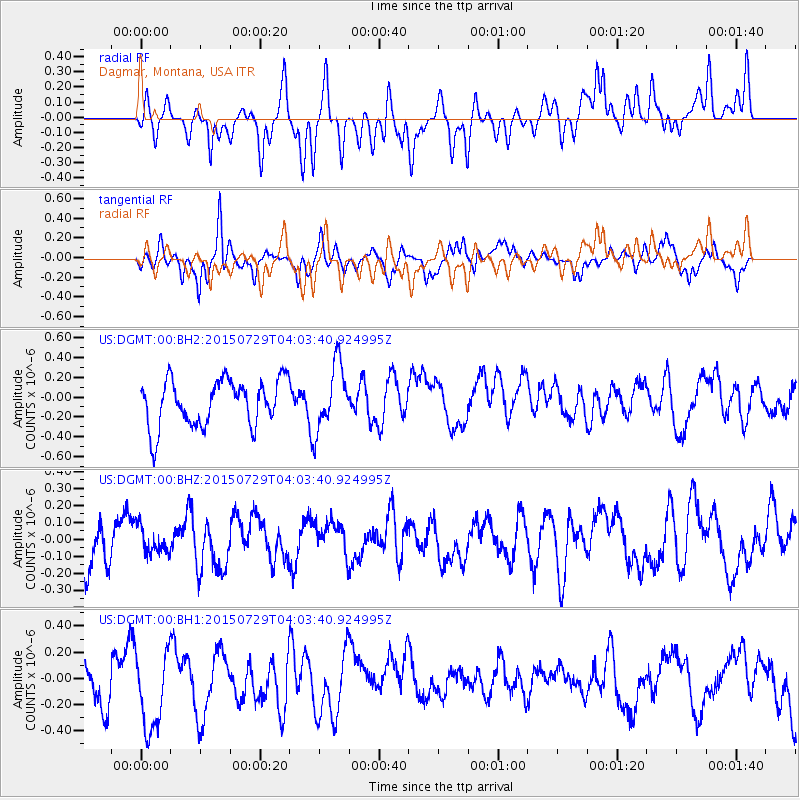
DGMT Dagmar, Montana, USA - Earthquake Result Viewer
*The percent match for this event was below the threshold and hence no stack was calculated.
| Earthquake location: |
Mariana Islands |
| Earthquake latitude/longitude: |
13.3/144.6 |
| Earthquake time(UTC): |
2015/07/29 (210) 03:51:06 GMT |
| Earthquake Depth: |
93 km |
| Earthquake Magnitude: |
4.9 mb |
| Earthquake Catalog/Contributor: |
ISC/ISC |
|
| Network: |
US United States National Seismic Network |
| Station: |
DGMT Dagmar, Montana, USA |
| Lat/Lon: |
48.47 N/104.20 W |
| Elevation: |
0.0 m |
|
| Distance: |
93.7 deg |
| Az: |
38.436 deg |
| Baz: |
294.587 deg |
| Ray Param: |
$rayparam |
*The percent match for this event was below the threshold and hence was not used in the summary stack. |
|
| Radial Match: |
30.885778 % |
| Radial Bump: |
400 |
| Transverse Match: |
54.020412 % |
| Transverse Bump: |
368 |
| SOD ConfigId: |
7422571 |
| Insert Time: |
2019-04-20 01:57:28.578 +0000 |
| GWidth: |
2.5 |
| Max Bumps: |
400 |
| Tol: |
0.001 |
|
Signal To Noise
| Channel | StoN | STA | LTA |
| US:DGMT:00:BHZ:20150729T04:03:40.924995Z | 0.6440224 | 7.65545E-8 | 1.1886931E-7 |
| US:DGMT:00:BH1:20150729T04:03:40.924995Z | 1.6504995 | 3.13495E-7 | 1.8993947E-7 |
| US:DGMT:00:BH2:20150729T04:03:40.924995Z | 1.4156195 | 3.340318E-7 | 2.3596156E-7 |
| Arrivals |
| Ps | |
| PpPs | |
| PsPs/PpSs | |


