You are here: Home > Network List > CI - Caltech Regional Seismic Network Stations List
> Station GLA Glamis, California, USA > Earthquake Result Viewer
GLA Glamis, California, USA - Earthquake Result Viewer
| Earthquake location: |
Northern Algeria |
| Earthquake latitude/longitude: |
37.0/3.6 |
| Earthquake time(UTC): |
2003/05/21 (141) 18:44:20 GMT |
| Earthquake Depth: |
12 km |
| Earthquake Magnitude: |
6.5 MB, 6.9 MS, 6.8 MW, 6.7 MW |
| Earthquake Catalog/Contributor: |
WHDF/NEIC |
|
| Network: |
CI Caltech Regional Seismic Network |
| Station: |
GLA Glamis, California, USA |
| Lat/Lon: |
33.05 N/114.83 W |
| Elevation: |
627 m |
|
| Distance: |
89.7 deg |
| Az: |
312.409 deg |
| Baz: |
44.761 deg |
| Ray Param: |
0.04172244 |
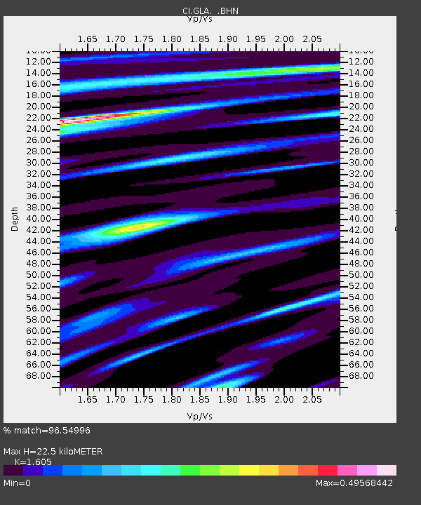
| Estimated Moho Depth: |
22.5 km |
| Estimated Crust Vp/Vs: |
1.61 |
| Assumed Crust Vp: |
6.155 km/s |
| Estimated Crust Vs: |
3.835 km/s |
| Estimated Crust Poisson's Ratio: |
0.18 |
|
| Radial Match: |
96.54996 % |
| Radial Bump: |
400 |
| Transverse Match: |
86.92121 % |
| Transverse Bump: |
400 |
| SOD ConfigId: |
3787 |
| Insert Time: |
2010-02-25 21:45:27.827 +0000 |
| GWidth: |
2.5 |
| Max Bumps: |
400 |
| Tol: |
0.001 |
|
Signal To Noise
| Channel | StoN | STA | LTA |
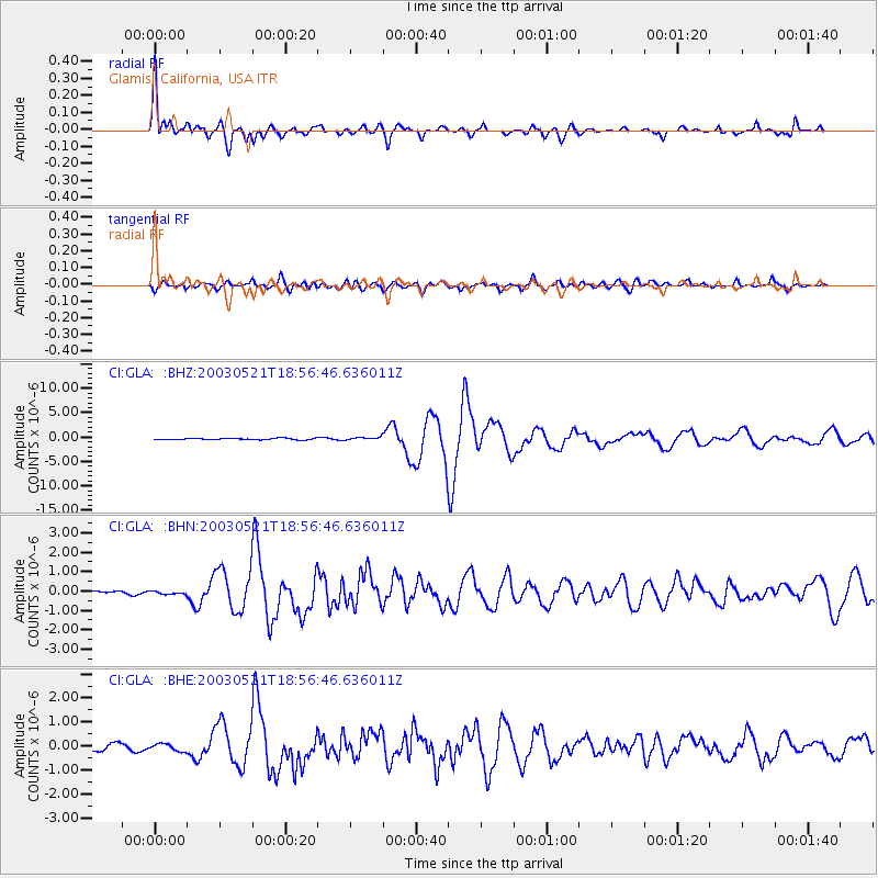
| CI:GLA: :BHN:20030521T18:56:46.636011Z | 1.2280477 | 7.557094E-8 | 6.153746E-8 |
| CI:GLA: :BHE:20030521T18:56:46.636011Z | 1.1659054 | 1.5222547E-7 | 1.3056417E-7 |
| CI:GLA: :BHZ:20030521T18:56:46.636011Z | 2.0138133 | 2.836165E-7 | 1.4083554E-7 |
| Arrivals |
| Ps | 2.3 SECOND |
| PpPs | 9.3 SECOND |
| PsPs/PpSs | 12 SECOND |


