You are here: Home > Network List > IU - Global Seismograph Network (GSN - IRIS/USGS) Stations List
> Station YSS Yuzhno Sakhalinsk, Russia > Earthquake Result Viewer
YSS Yuzhno Sakhalinsk, Russia - Earthquake Result Viewer
| Earthquake location: |
Kermadec Islands Region |
| Earthquake latitude/longitude: |
-31.8/-179.3 |
| Earthquake time(UTC): |
2006/05/16 (136) 10:39:23 GMT |
| Earthquake Depth: |
152 km |
| Earthquake Magnitude: |
6.8 MB, 7.4 MW, 7.4 MW |
| Earthquake Catalog/Contributor: |
WHDF/NEIC |
|
| Network: |
IU Global Seismograph Network (GSN - IRIS/USGS) |
| Station: |
YSS Yuzhno Sakhalinsk, Russia |
| Lat/Lon: |
46.96 N/142.76 E |
| Elevation: |
100 m |
|
| Distance: |
85.5 deg |
| Az: |
335.019 deg |
| Baz: |
148.326 deg |
| Ray Param: |
0.04437205 |
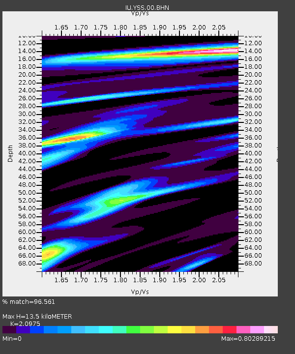
| Estimated Moho Depth: |
13.5 km |
| Estimated Crust Vp/Vs: |
2.10 |
| Assumed Crust Vp: |
6.468 km/s |
| Estimated Crust Vs: |
3.084 km/s |
| Estimated Crust Poisson's Ratio: |
0.35 |
|
| Radial Match: |
96.561 % |
| Radial Bump: |
330 |
| Transverse Match: |
95.232346 % |
| Transverse Bump: |
400 |
| SOD ConfigId: |
2669 |
| Insert Time: |
2010-03-04 14:19:41.866 +0000 |
| GWidth: |
2.5 |
| Max Bumps: |
400 |
| Tol: |
0.001 |
|
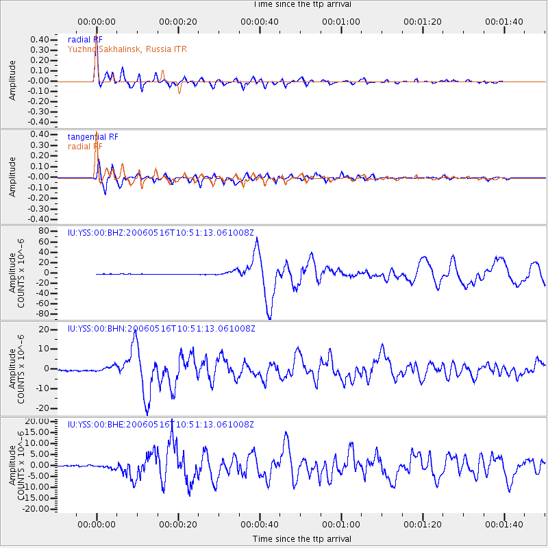
Signal To Noise
| Channel | StoN | STA | LTA |
| IU:YSS:00:BHN:20060516T10:51:13.061008Z | 5.671076 | 1.5144426E-6 | 2.670468E-7 |
| IU:YSS:00:BHE:20060516T10:51:13.061008Z | 3.492885 | 7.7593245E-7 | 2.2214657E-7 |
| IU:YSS:00:BHZ:20060516T10:51:13.061008Z | 13.927746 | 5.2826645E-6 | 3.792907E-7 |
| Arrivals |
| Ps | 2.3 SECOND |
| PpPs | 6.3 SECOND |
| PsPs/PpSs | 8.7 SECOND |


