You are here: Home > Network List > BK - Berkeley Digital Seismograph Network Stations List
> Station HUMO Hull Mountain, OR > Earthquake Result Viewer
HUMO Hull Mountain, OR - Earthquake Result Viewer
| Earthquake location: |
New Britain Region, P.N.G. |
| Earthquake latitude/longitude: |
-4.7/152.6 |
| Earthquake time(UTC): |
2015/03/29 (088) 23:48:34 GMT |
| Earthquake Depth: |
66 km |
| Earthquake Magnitude: |
7.7 MWP, 7.6 MI |
| Earthquake Catalog/Contributor: |
NEIC PDE/NEIC COMCAT |
|
| Network: |
BK Berkeley Digital Seismograph Network |
| Station: |
HUMO Hull Mountain, OR |
| Lat/Lon: |
42.61 N/122.96 W |
| Elevation: |
555 m |
|
| Distance: |
89.1 deg |
| Az: |
47.302 deg |
| Baz: |
262.801 deg |
| Ray Param: |
0.0419615 |
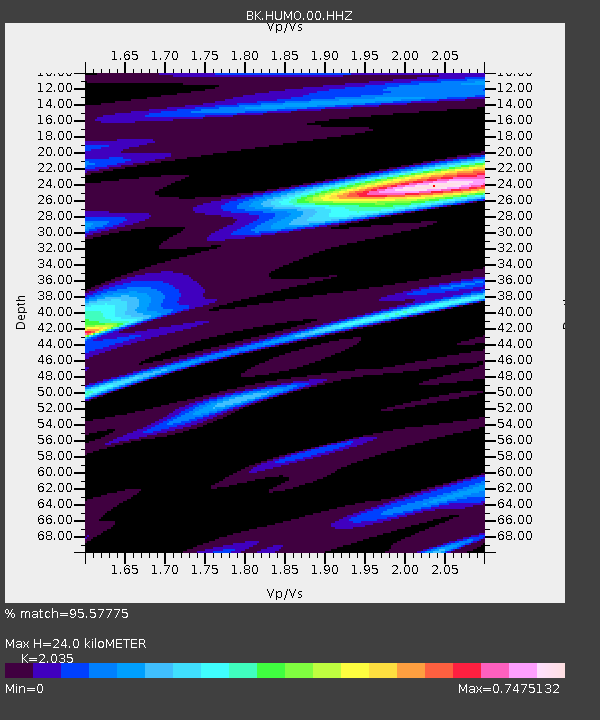
| Estimated Moho Depth: |
24.0 km |
| Estimated Crust Vp/Vs: |
2.04 |
| Assumed Crust Vp: |
6.522 km/s |
| Estimated Crust Vs: |
3.205 km/s |
| Estimated Crust Poisson's Ratio: |
0.34 |
|
| Radial Match: |
95.57775 % |
| Radial Bump: |
341 |
| Transverse Match: |
61.601143 % |
| Transverse Bump: |
400 |
| SOD ConfigId: |
872571 |
| Insert Time: |
2015-04-13 00:03:44.602 +0000 |
| GWidth: |
2.5 |
| Max Bumps: |
400 |
| Tol: |
0.001 |
|
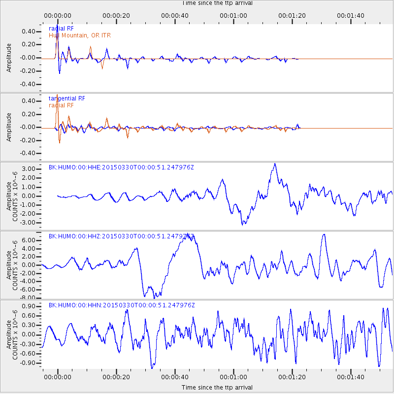
Signal To Noise
| Channel | StoN | STA | LTA |
| BK:HUMO:00:HHZ:20150330T00:00:51.247976Z | 2.1336484 | 7.7496844E-7 | 3.6321282E-7 |
| BK:HUMO:00:HHN:20150330T00:00:51.247976Z | 1.4473156 | 2.3623105E-7 | 1.6322012E-7 |
| BK:HUMO:00:HHE:20150330T00:00:51.247976Z | 1.1214771 | 2.8049033E-7 | 2.5010795E-7 |
| Arrivals |
| Ps | 3.9 SECOND |
| PpPs | 11 SECOND |
| PsPs/PpSs | 15 SECOND |


