You are here: Home > Network List > G - GEOSCOPE Stations List
> Station INU Inuyama, Japan > Earthquake Result Viewer
INU Inuyama, Japan - Earthquake Result Viewer
| Earthquake location: |
New Britain Region, P.N.G. |
| Earthquake latitude/longitude: |
-4.7/152.6 |
| Earthquake time(UTC): |
2015/03/29 (088) 23:48:34 GMT |
| Earthquake Depth: |
66 km |
| Earthquake Magnitude: |
7.7 MWP, 7.6 MI |
| Earthquake Catalog/Contributor: |
NEIC PDE/NEIC COMCAT |
|
| Network: |
G GEOSCOPE |
| Station: |
INU Inuyama, Japan |
| Lat/Lon: |
35.35 N/137.03 E |
| Elevation: |
132 m |
|
| Distance: |
42.5 deg |
| Az: |
341.085 deg |
| Baz: |
156.721 deg |
| Ray Param: |
0.07296312 |
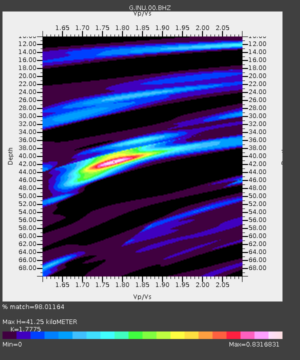
| Estimated Moho Depth: |
41.25 km |
| Estimated Crust Vp/Vs: |
1.78 |
| Assumed Crust Vp: |
6.461 km/s |
| Estimated Crust Vs: |
3.635 km/s |
| Estimated Crust Poisson's Ratio: |
0.27 |
|
| Radial Match: |
98.01164 % |
| Radial Bump: |
253 |
| Transverse Match: |
94.614136 % |
| Transverse Bump: |
400 |
| SOD ConfigId: |
872571 |
| Insert Time: |
2015-04-13 00:04:12.996 +0000 |
| GWidth: |
2.5 |
| Max Bumps: |
400 |
| Tol: |
0.001 |
|

Signal To Noise
| Channel | StoN | STA | LTA |
| G:INU:00:BHZ:20150329T23:55:52.460989Z | 5.658426 | 1.3088155E-6 | 2.3130382E-7 |
| G:INU:00:BHN:20150329T23:55:52.460989Z | 3.430412 | 6.711982E-7 | 1.956611E-7 |
| G:INU:00:BHE:20150329T23:55:52.460989Z | 2.209238 | 2.2405492E-7 | 1.01417285E-7 |
| Arrivals |
| Ps | 5.3 SECOND |
| PpPs | 17 SECOND |
| PsPs/PpSs | 22 SECOND |


