You are here: Home > Network List > TA - USArray Transportable Network (new EarthScope stations) Stations List
> Station MSTX Muleshoe, TX, USA > Earthquake Result Viewer
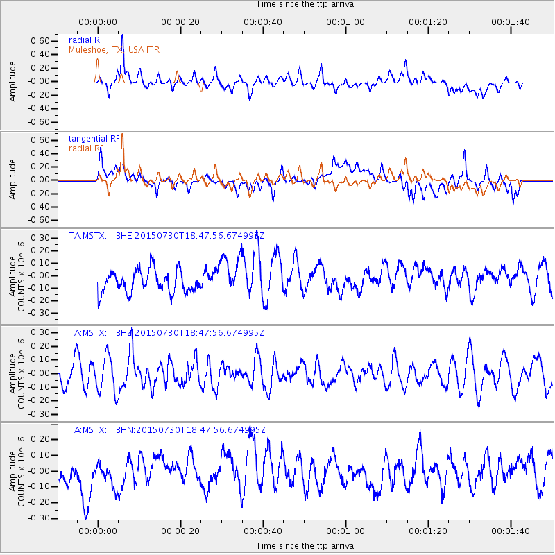
MSTX Muleshoe, TX, USA - Earthquake Result Viewer
*The percent match for this event was below the threshold and hence no stack was calculated.
| Earthquake location: |
Kermadec Islands Region |
| Earthquake latitude/longitude: |
-27.2/-176.2 |
| Earthquake time(UTC): |
2015/07/30 (211) 18:35:17 GMT |
| Earthquake Depth: |
12 km |
| Earthquake Magnitude: |
5.5 MW |
| Earthquake Catalog/Contributor: |
ISC/ISC |
|
| Network: |
TA USArray Transportable Network (new EarthScope stations) |
| Station: |
MSTX Muleshoe, TX, USA |
| Lat/Lon: |
33.97 N/102.77 W |
| Elevation: |
1167 m |
|
| Distance: |
92.4 deg |
| Az: |
52.851 deg |
| Baz: |
238.639 deg |
| Ray Param: |
$rayparam |
*The percent match for this event was below the threshold and hence was not used in the summary stack. |
|
| Radial Match: |
58.67755 % |
| Radial Bump: |
400 |
| Transverse Match: |
50.338886 % |
| Transverse Bump: |
400 |
| SOD ConfigId: |
7422571 |
| Insert Time: |
2019-04-20 02:28:57.051 +0000 |
| GWidth: |
2.5 |
| Max Bumps: |
400 |
| Tol: |
0.001 |
|
Signal To Noise
| Channel | StoN | STA | LTA |
| TA:MSTX: :BHZ:20150730T18:47:56.674995Z | 1.833314 | 1.3544364E-7 | 7.3879136E-8 |
| TA:MSTX: :BHN:20150730T18:47:56.674995Z | 0.6900555 | 1.0167733E-7 | 1.473466E-7 |
| TA:MSTX: :BHE:20150730T18:47:56.674995Z | 1.8848501 | 1.646076E-7 | 8.733193E-8 |
| Arrivals |
| Ps | |
| PpPs | |
| PsPs/PpSs | |


