You are here: Home > Network List > UU - University of Utah Regional Network Stations List
> Station BGU Big Grassy Mountain, UT, USA > Earthquake Result Viewer
BGU Big Grassy Mountain, UT, USA - Earthquake Result Viewer
| Earthquake location: |
New Britain Region, P.N.G. |
| Earthquake latitude/longitude: |
-4.7/152.6 |
| Earthquake time(UTC): |
2015/03/29 (088) 23:48:34 GMT |
| Earthquake Depth: |
66 km |
| Earthquake Magnitude: |
7.7 MWP, 7.6 MI |
| Earthquake Catalog/Contributor: |
NEIC PDE/NEIC COMCAT |
|
| Network: |
UU University of Utah Regional Network |
| Station: |
BGU Big Grassy Mountain, UT, USA |
| Lat/Lon: |
40.92 N/113.03 W |
| Elevation: |
1640 m |
|
| Distance: |
96.4 deg |
| Az: |
49.491 deg |
| Baz: |
269.292 deg |
| Ray Param: |
0.040476378 |
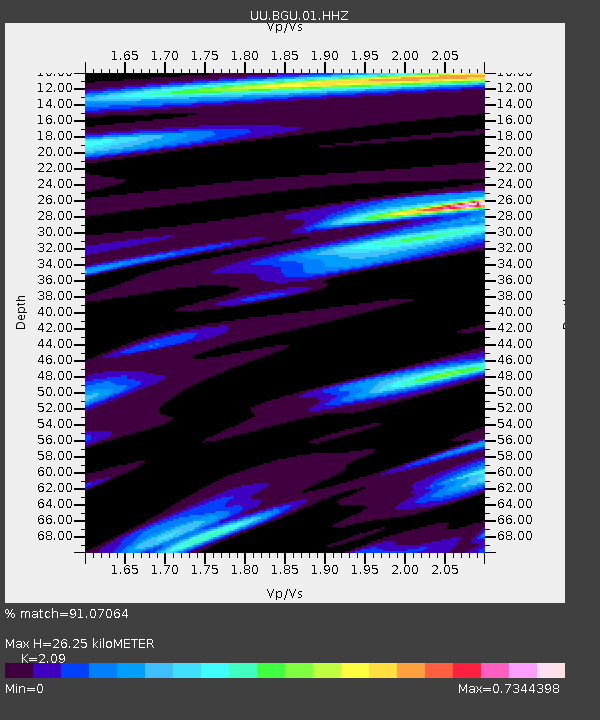
| Estimated Moho Depth: |
26.25 km |
| Estimated Crust Vp/Vs: |
2.09 |
| Assumed Crust Vp: |
6.276 km/s |
| Estimated Crust Vs: |
3.003 km/s |
| Estimated Crust Poisson's Ratio: |
0.35 |
|
| Radial Match: |
91.07064 % |
| Radial Bump: |
400 |
| Transverse Match: |
74.830986 % |
| Transverse Bump: |
400 |
| SOD ConfigId: |
872571 |
| Insert Time: |
2015-04-13 00:08:24.122 +0000 |
| GWidth: |
2.5 |
| Max Bumps: |
400 |
| Tol: |
0.001 |
|

Signal To Noise
| Channel | StoN | STA | LTA |
| UU:BGU:01:HHZ:20150330T00:01:24.65801Z | 1.9400781 | 8.01371E-9 | 4.1306114E-9 |
| UU:BGU:01:HHN:20150330T00:01:24.65801Z | 1.6545513 | 5.1610503E-9 | 3.1193053E-9 |
| UU:BGU:01:HHE:20150330T00:01:24.65801Z | 1.1889386 | 5.97426E-9 | 5.0248685E-9 |
| Arrivals |
| Ps | 4.6 SECOND |
| PpPs | 13 SECOND |
| PsPs/PpSs | 17 SECOND |


