You are here: Home > Network List > GS - US Geological Survey Networks Stations List
> Station KAN08 Pence Farm, Harper, KS, USA > Earthquake Result Viewer
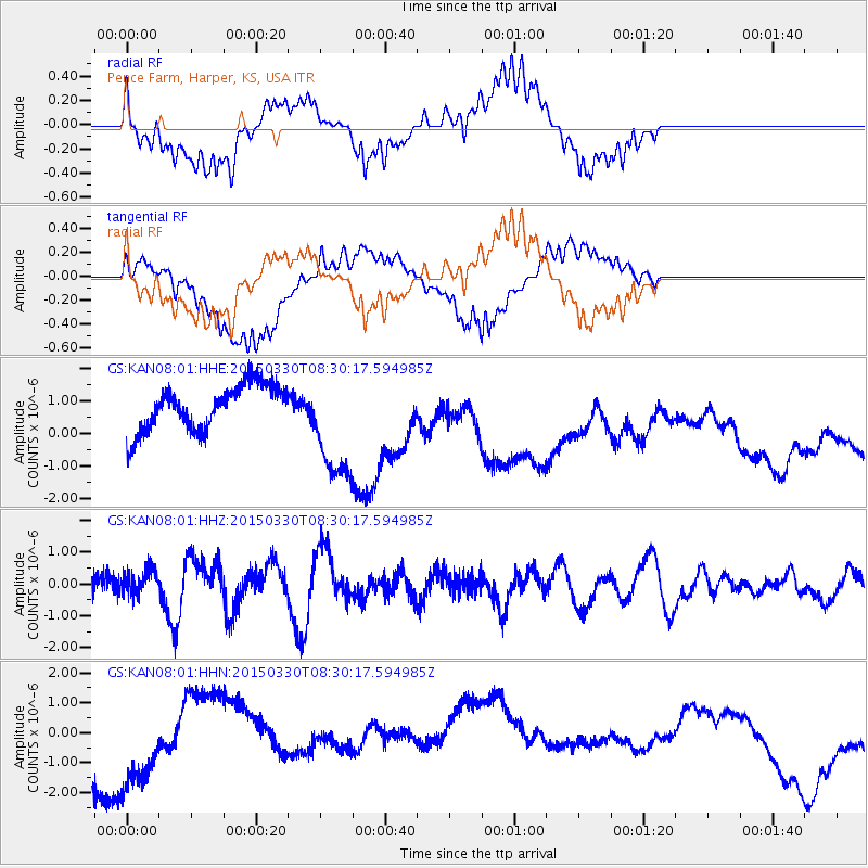
KAN08 Pence Farm, Harper, KS, USA - Earthquake Result Viewer
*The percent match for this event was below the threshold and hence no stack was calculated.
| Earthquake location: |
Samoa Islands Region |
| Earthquake latitude/longitude: |
-15.4/-172.9 |
| Earthquake time(UTC): |
2015/03/30 (089) 08:18:00 GMT |
| Earthquake Depth: |
10 km |
| Earthquake Magnitude: |
6.8 MWP, 6.8 MI |
| Earthquake Catalog/Contributor: |
NEIC PDE/NEIC COMCAT |
|
| Network: |
GS US Geological Survey Networks |
| Station: |
KAN08 Pence Farm, Harper, KS, USA |
| Lat/Lon: |
37.23 N/97.97 W |
| Elevation: |
375 m |
|
| Distance: |
87.7 deg |
| Az: |
50.483 deg |
| Baz: |
248.775 deg |
| Ray Param: |
$rayparam |
*The percent match for this event was below the threshold and hence was not used in the summary stack. |
|
| Radial Match: |
30.093084 % |
| Radial Bump: |
400 |
| Transverse Match: |
27.818958 % |
| Transverse Bump: |
400 |
| SOD ConfigId: |
872571 |
| Insert Time: |
2015-04-13 08:25:58.419 +0000 |
| GWidth: |
2.5 |
| Max Bumps: |
400 |
| Tol: |
0.001 |
|
Signal To Noise
| Channel | StoN | STA | LTA |
| GS:KAN08:01:HHZ:20150330T08:30:17.594985Z | 1.5525032 | 4.2971755E-7 | 2.767901E-7 |
| GS:KAN08:01:HHN:20150330T08:30:17.594985Z | 1.9430614 | 1.4624137E-6 | 7.526338E-7 |
| GS:KAN08:01:HHE:20150330T08:30:17.594985Z | 2.4977853 | 1.7241842E-6 | 6.902852E-7 |
| Arrivals |
| Ps | |
| PpPs | |
| PsPs/PpSs | |


