You are here: Home > Network List > AK - Alaska Regional Network Stations List
> Station MDM Murphy Dome > Earthquake Result Viewer
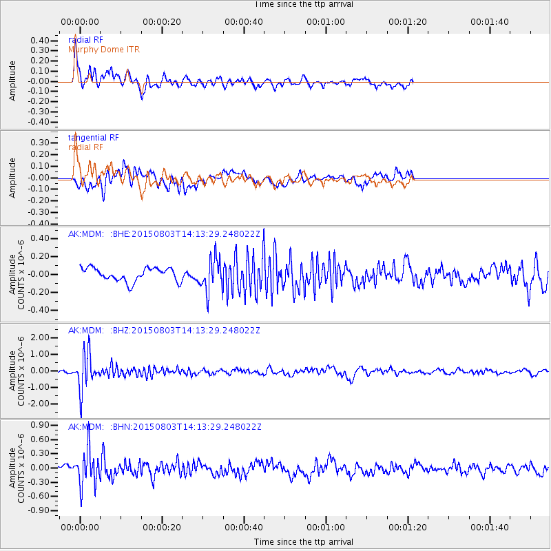
MDM Murphy Dome - Earthquake Result Viewer
*The percent match for this event was below the threshold and hence no stack was calculated.
| Earthquake location: |
Tonga Islands |
| Earthquake latitude/longitude: |
-16.5/-174.3 |
| Earthquake time(UTC): |
2015/08/03 (215) 14:01:51 GMT |
| Earthquake Depth: |
162 km |
| Earthquake Magnitude: |
5.7 MWB, 5.7 MWW |
| Earthquake Catalog/Contributor: |
NEIC PDE/NEIC COMCAT |
|
| Network: |
AK Alaska Regional Network |
| Station: |
MDM Murphy Dome |
| Lat/Lon: |
64.96 N/148.23 W |
| Elevation: |
634 m |
|
| Distance: |
83.6 deg |
| Az: |
10.864 deg |
| Baz: |
205.146 deg |
| Ray Param: |
$rayparam |
*The percent match for this event was below the threshold and hence was not used in the summary stack. |
|
| Radial Match: |
75.94641 % |
| Radial Bump: |
400 |
| Transverse Match: |
75.09769 % |
| Transverse Bump: |
400 |
| SOD ConfigId: |
7422571 |
| Insert Time: |
2019-04-20 03:24:31.502 +0000 |
| GWidth: |
2.5 |
| Max Bumps: |
400 |
| Tol: |
0.001 |
|
Signal To Noise
| Channel | StoN | STA | LTA |
| AK:MDM: :BHZ:20150803T14:13:29.248022Z | 10.588956 | 1.1045177E-6 | 1.0430845E-7 |
| AK:MDM: :BHN:20150803T14:13:29.248022Z | 5.0006843 | 3.8489827E-7 | 7.6969116E-8 |
| AK:MDM: :BHE:20150803T14:13:29.248022Z | 2.4840236 | 1.821723E-7 | 7.3337596E-8 |
| Arrivals |
| Ps | |
| PpPs | |
| PsPs/PpSs | |


