You are here: Home > Network List > CI - Caltech Regional Seismic Network Stations List
> Station MPP McPhearson Peak > Earthquake Result Viewer
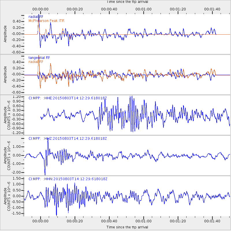
MPP McPhearson Peak - Earthquake Result Viewer
*The percent match for this event was below the threshold and hence no stack was calculated.
| Earthquake location: |
Tonga Islands |
| Earthquake latitude/longitude: |
-16.5/-174.3 |
| Earthquake time(UTC): |
2015/08/03 (215) 14:01:51 GMT |
| Earthquake Depth: |
162 km |
| Earthquake Magnitude: |
5.7 MWB, 5.7 MWW |
| Earthquake Catalog/Contributor: |
NEIC PDE/NEIC COMCAT |
|
| Network: |
CI Caltech Regional Seismic Network |
| Station: |
MPP McPhearson Peak |
| Lat/Lon: |
34.89 N/119.81 W |
| Elevation: |
1739 m |
|
| Distance: |
72.7 deg |
| Az: |
44.522 deg |
| Baz: |
234.927 deg |
| Ray Param: |
$rayparam |
*The percent match for this event was below the threshold and hence was not used in the summary stack. |
|
| Radial Match: |
72.45694 % |
| Radial Bump: |
400 |
| Transverse Match: |
52.076687 % |
| Transverse Bump: |
400 |
| SOD ConfigId: |
7422571 |
| Insert Time: |
2019-04-20 03:26:57.374 +0000 |
| GWidth: |
2.5 |
| Max Bumps: |
400 |
| Tol: |
0.001 |
|
Signal To Noise
| Channel | StoN | STA | LTA |
| CI:MPP: :HHZ:20150803T14:12:29.618018Z | 6.56355 | 8.807103E-7 | 1.34182E-7 |
| CI:MPP: :HHN:20150803T14:12:29.618018Z | 1.9130405 | 4.326423E-7 | 2.2615428E-7 |
| CI:MPP: :HHE:20150803T14:12:29.618018Z | 2.1735485 | 3.9587349E-7 | 1.8213235E-7 |
| Arrivals |
| Ps | |
| PpPs | |
| PsPs/PpSs | |


