You are here: Home > Network List > TA - USArray Transportable Network (new EarthScope stations) Stations List
> Station MSTX Muleshoe, TX, USA > Earthquake Result Viewer
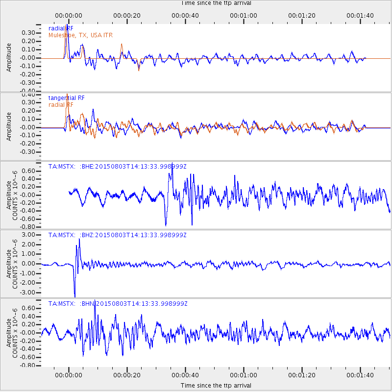
MSTX Muleshoe, TX, USA - Earthquake Result Viewer
*The percent match for this event was below the threshold and hence no stack was calculated.
| Earthquake location: |
Tonga Islands |
| Earthquake latitude/longitude: |
-16.5/-174.3 |
| Earthquake time(UTC): |
2015/08/03 (215) 14:01:51 GMT |
| Earthquake Depth: |
162 km |
| Earthquake Magnitude: |
5.7 MWB, 5.7 MWW |
| Earthquake Catalog/Contributor: |
NEIC PDE/NEIC COMCAT |
|
| Network: |
TA USArray Transportable Network (new EarthScope stations) |
| Station: |
MSTX Muleshoe, TX, USA |
| Lat/Lon: |
33.97 N/102.77 W |
| Elevation: |
1167 m |
|
| Distance: |
84.5 deg |
| Az: |
52.377 deg |
| Baz: |
246.129 deg |
| Ray Param: |
$rayparam |
*The percent match for this event was below the threshold and hence was not used in the summary stack. |
|
| Radial Match: |
74.27118 % |
| Radial Bump: |
400 |
| Transverse Match: |
66.75756 % |
| Transverse Bump: |
400 |
| SOD ConfigId: |
7422571 |
| Insert Time: |
2019-04-20 03:31:09.355 +0000 |
| GWidth: |
2.5 |
| Max Bumps: |
400 |
| Tol: |
0.001 |
|
Signal To Noise
| Channel | StoN | STA | LTA |
| TA:MSTX: :BHZ:20150803T14:13:33.998999Z | 14.467822 | 1.1820089E-6 | 8.1699156E-8 |
| TA:MSTX: :BHN:20150803T14:13:33.998999Z | 1.3494385 | 1.5978651E-7 | 1.1840962E-7 |
| TA:MSTX: :BHE:20150803T14:13:33.998999Z | 3.3962426 | 3.6068826E-7 | 1.0620215E-7 |
| Arrivals |
| Ps | |
| PpPs | |
| PsPs/PpSs | |


