You are here: Home > Network List > TA - USArray Transportable Network (new EarthScope stations) Stations List
> Station O03E Paynes Creek, CA, USA > Earthquake Result Viewer
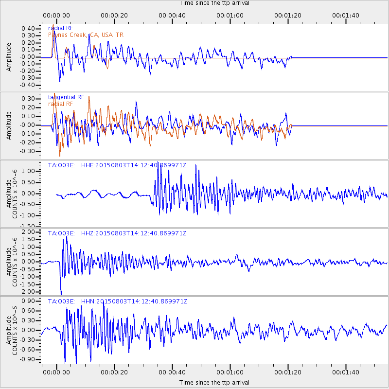
O03E Paynes Creek, CA, USA - Earthquake Result Viewer
*The percent match for this event was below the threshold and hence no stack was calculated.
| Earthquake location: |
Tonga Islands |
| Earthquake latitude/longitude: |
-16.5/-174.3 |
| Earthquake time(UTC): |
2015/08/03 (215) 14:01:51 GMT |
| Earthquake Depth: |
162 km |
| Earthquake Magnitude: |
5.7 MWB, 5.7 MWW |
| Earthquake Catalog/Contributor: |
NEIC PDE/NEIC COMCAT |
|
| Network: |
TA USArray Transportable Network (new EarthScope stations) |
| Station: |
O03E Paynes Creek, CA, USA |
| Lat/Lon: |
40.29 N/121.80 W |
| Elevation: |
967 m |
|
| Distance: |
74.6 deg |
| Az: |
39.021 deg |
| Baz: |
232.169 deg |
| Ray Param: |
$rayparam |
*The percent match for this event was below the threshold and hence was not used in the summary stack. |
|
| Radial Match: |
72.54439 % |
| Radial Bump: |
400 |
| Transverse Match: |
67.14099 % |
| Transverse Bump: |
400 |
| SOD ConfigId: |
7422571 |
| Insert Time: |
2019-04-20 03:31:13.447 +0000 |
| GWidth: |
2.5 |
| Max Bumps: |
400 |
| Tol: |
0.001 |
|
Signal To Noise
| Channel | StoN | STA | LTA |
| TA:O03E: :HHZ:20150803T14:12:40.869971Z | 9.152021 | 8.9643834E-7 | 9.7949766E-8 |
| TA:O03E: :HHN:20150803T14:12:40.869971Z | 3.1744492 | 3.5247413E-7 | 1.1103474E-7 |
| TA:O03E: :HHE:20150803T14:12:40.869971Z | 4.8958826 | 4.5613234E-7 | 9.316651E-8 |
| Arrivals |
| Ps | |
| PpPs | |
| PsPs/PpSs | |


