You are here: Home > Network List > TA - USArray Transportable Network (new EarthScope stations) Stations List
> Station P19K Oil Pt, AK, USA > Earthquake Result Viewer
P19K Oil Pt, AK, USA - Earthquake Result Viewer
| Earthquake location: |
Tonga Islands |
| Earthquake latitude/longitude: |
-16.5/-174.3 |
| Earthquake time(UTC): |
2015/08/03 (215) 14:01:51 GMT |
| Earthquake Depth: |
162 km |
| Earthquake Magnitude: |
5.7 MWB, 5.7 MWW |
| Earthquake Catalog/Contributor: |
NEIC PDE/NEIC COMCAT |
|
| Network: |
TA USArray Transportable Network (new EarthScope stations) |
| Station: |
P19K Oil Pt, AK, USA |
| Lat/Lon: |
59.65 N/153.23 W |
| Elevation: |
629 m |
|
| Distance: |
77.8 deg |
| Az: |
10.783 deg |
| Baz: |
200.705 deg |
| Ray Param: |
0.049695436 |
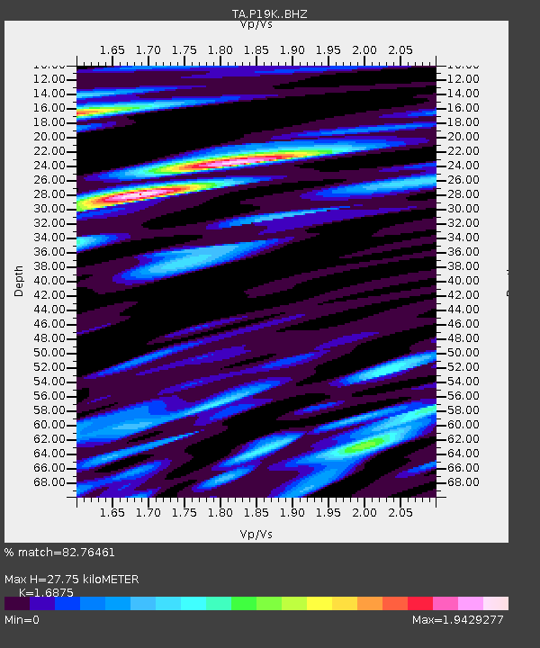
| Estimated Moho Depth: |
27.75 km |
| Estimated Crust Vp/Vs: |
1.69 |
| Assumed Crust Vp: |
5.989 km/s |
| Estimated Crust Vs: |
3.549 km/s |
| Estimated Crust Poisson's Ratio: |
0.23 |
|
| Radial Match: |
82.76461 % |
| Radial Bump: |
400 |
| Transverse Match: |
71.39259 % |
| Transverse Bump: |
400 |
| SOD ConfigId: |
7422571 |
| Insert Time: |
2019-04-20 03:31:15.254 +0000 |
| GWidth: |
2.5 |
| Max Bumps: |
400 |
| Tol: |
0.001 |
|

Signal To Noise
| Channel | StoN | STA | LTA |
| TA:P19K: :BHZ:20150803T14:12:58.475012Z | 12.177902 | 1.5214645E-6 | 1.2493649E-7 |
| TA:P19K: :BHN:20150803T14:12:58.475012Z | 9.97041 | 1.0752387E-6 | 1.07842986E-7 |
| TA:P19K: :BHE:20150803T14:12:58.475012Z | 6.0687175 | 7.903338E-7 | 1.3023077E-7 |
| Arrivals |
| Ps | 3.3 SECOND |
| PpPs | 12 SECOND |
| PsPs/PpSs | 15 SECOND |


