You are here: Home > Network List > TA - USArray Transportable Network (new EarthScope stations) Stations List
> Station Z41A Richland Creek Farm, El Dorado, AR, USA > Earthquake Result Viewer
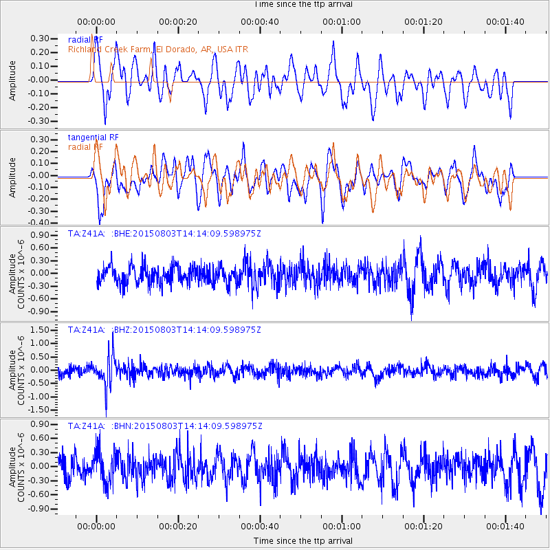
Z41A Richland Creek Farm, El Dorado, AR, USA - Earthquake Result Viewer
*The percent match for this event was below the threshold and hence no stack was calculated.
| Earthquake location: |
Tonga Islands |
| Earthquake latitude/longitude: |
-16.5/-174.3 |
| Earthquake time(UTC): |
2015/08/03 (215) 14:01:51 GMT |
| Earthquake Depth: |
162 km |
| Earthquake Magnitude: |
5.7 MWB, 5.7 MWW |
| Earthquake Catalog/Contributor: |
NEIC PDE/NEIC COMCAT |
|
| Network: |
TA USArray Transportable Network (new EarthScope stations) |
| Station: |
Z41A Richland Creek Farm, El Dorado, AR, USA |
| Lat/Lon: |
33.26 N/92.80 W |
| Elevation: |
62 m |
|
| Distance: |
92.0 deg |
| Az: |
56.026 deg |
| Baz: |
251.742 deg |
| Ray Param: |
$rayparam |
*The percent match for this event was below the threshold and hence was not used in the summary stack. |
|
| Radial Match: |
59.4689 % |
| Radial Bump: |
400 |
| Transverse Match: |
45.59641 % |
| Transverse Bump: |
397 |
| SOD ConfigId: |
7422571 |
| Insert Time: |
2019-04-20 03:31:30.056 +0000 |
| GWidth: |
2.5 |
| Max Bumps: |
400 |
| Tol: |
0.001 |
|
Signal To Noise
| Channel | StoN | STA | LTA |
| TA:Z41A: :BHZ:20150803T14:14:09.598975Z | 3.3533125 | 5.8265476E-7 | 1.7375498E-7 |
| TA:Z41A: :BHN:20150803T14:14:09.598975Z | 1.5707477 | 3.479025E-7 | 2.2148846E-7 |
| TA:Z41A: :BHE:20150803T14:14:09.598975Z | 0.98626304 | 1.9766757E-7 | 2.0042076E-7 |
| Arrivals |
| Ps | |
| PpPs | |
| PsPs/PpSs | |


