You are here: Home > Network List > WY - Yellowstone Wyoming Seismic Network Stations List
> Station YHL Hebgen Lake, YNP, WY, USA > Earthquake Result Viewer
YHL Hebgen Lake, YNP, WY, USA - Earthquake Result Viewer
| Earthquake location: |
Samoa Islands Region |
| Earthquake latitude/longitude: |
-15.4/-172.9 |
| Earthquake time(UTC): |
2015/03/30 (089) 08:18:00 GMT |
| Earthquake Depth: |
10 km |
| Earthquake Magnitude: |
6.8 MWP, 6.8 MI |
| Earthquake Catalog/Contributor: |
NEIC PDE/NEIC COMCAT |
|
| Network: |
WY Yellowstone Wyoming Seismic Network |
| Station: |
YHL Hebgen Lake, YNP, WY, USA |
| Lat/Lon: |
44.85 N/111.18 W |
| Elevation: |
2691 m |
|
| Distance: |
82.0 deg |
| Az: |
39.245 deg |
| Baz: |
239.074 deg |
| Ray Param: |
0.04719729 |
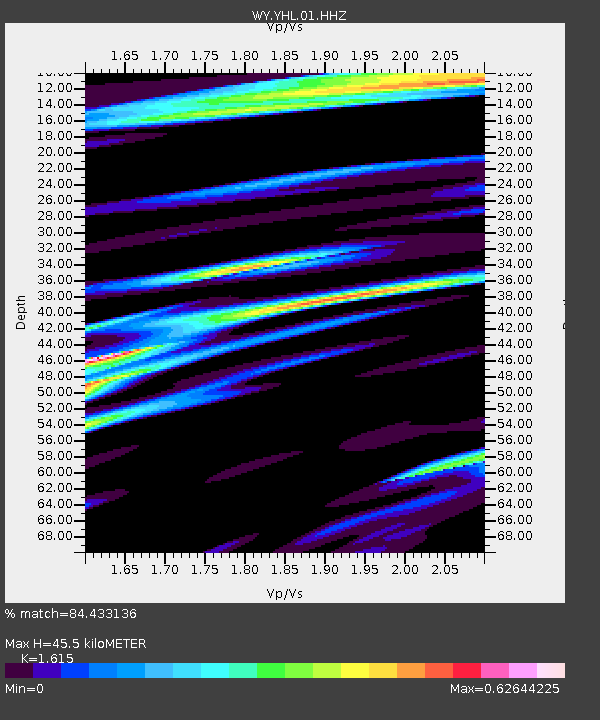
| Estimated Moho Depth: |
45.5 km |
| Estimated Crust Vp/Vs: |
1.62 |
| Assumed Crust Vp: |
6.35 km/s |
| Estimated Crust Vs: |
3.932 km/s |
| Estimated Crust Poisson's Ratio: |
0.19 |
|
| Radial Match: |
84.433136 % |
| Radial Bump: |
400 |
| Transverse Match: |
45.66623 % |
| Transverse Bump: |
400 |
| SOD ConfigId: |
872571 |
| Insert Time: |
2015-04-13 08:31:00.696 +0000 |
| GWidth: |
2.5 |
| Max Bumps: |
400 |
| Tol: |
0.001 |
|

Signal To Noise
| Channel | StoN | STA | LTA |
| WY:YHL:01:HHZ:20150330T08:29:49.198013Z | 1.9770402 | 9.546821E-9 | 4.8288453E-9 |
| WY:YHL:01:HHN:20150330T08:29:49.198013Z | 0.89509225 | 4.4496957E-9 | 4.971215E-9 |
| WY:YHL:01:HHE:20150330T08:29:49.198013Z | 0.7833922 | 4.5855706E-9 | 5.8534804E-9 |
| Arrivals |
| Ps | 4.5 SECOND |
| PpPs | 18 SECOND |
| PsPs/PpSs | 23 SECOND |


