You are here: Home > Network List > UW - Pacific Northwest Regional Seismic Network Stations List
> Station HOOD Mt Hood Meadows, OR CREST BB SMO > Earthquake Result Viewer
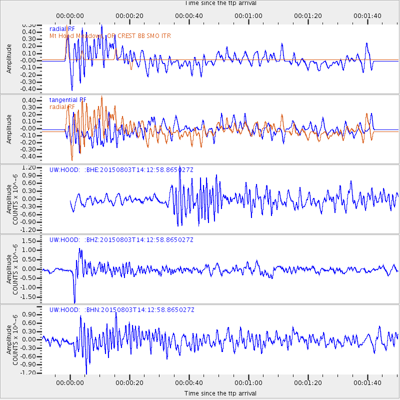
HOOD Mt Hood Meadows, OR CREST BB SMO - Earthquake Result Viewer
*The percent match for this event was below the threshold and hence no stack was calculated.
| Earthquake location: |
Tonga Islands |
| Earthquake latitude/longitude: |
-16.5/-174.3 |
| Earthquake time(UTC): |
2015/08/03 (215) 14:01:51 GMT |
| Earthquake Depth: |
162 km |
| Earthquake Magnitude: |
5.7 MWB, 5.7 MWW |
| Earthquake Catalog/Contributor: |
NEIC PDE/NEIC COMCAT |
|
| Network: |
UW Pacific Northwest Regional Seismic Network |
| Station: |
HOOD Mt Hood Meadows, OR CREST BB SMO |
| Lat/Lon: |
45.32 N/121.65 W |
| Elevation: |
1520 m |
|
| Distance: |
77.8 deg |
| Az: |
35.029 deg |
| Baz: |
231.32 deg |
| Ray Param: |
$rayparam |
*The percent match for this event was below the threshold and hence was not used in the summary stack. |
|
| Radial Match: |
66.23487 % |
| Radial Bump: |
400 |
| Transverse Match: |
61.091366 % |
| Transverse Bump: |
400 |
| SOD ConfigId: |
7422571 |
| Insert Time: |
2019-04-20 03:32:27.274 +0000 |
| GWidth: |
2.5 |
| Max Bumps: |
400 |
| Tol: |
0.001 |
|
Signal To Noise
| Channel | StoN | STA | LTA |
| UW:HOOD: :BHZ:20150803T14:12:58.865027Z | 6.4835615 | 6.734009E-7 | 1.0386281E-7 |
| UW:HOOD: :BHN:20150803T14:12:58.865027Z | 2.7921414 | 3.6488376E-7 | 1.3068241E-7 |
| UW:HOOD: :BHE:20150803T14:12:58.865027Z | 2.0785825 | 2.7919666E-7 | 1.343207E-7 |
| Arrivals |
| Ps | |
| PpPs | |
| PsPs/PpSs | |


