You are here: Home > Network List > UW - Pacific Northwest Regional Seismic Network Stations List
> Station PASS Maple Falls, WA, USA > Earthquake Result Viewer
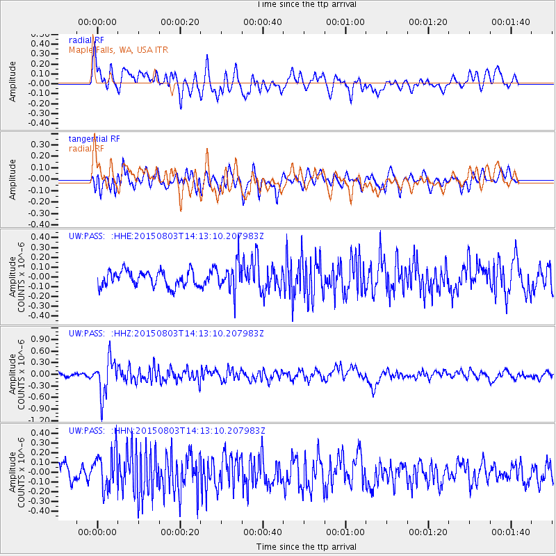
PASS Maple Falls, WA, USA - Earthquake Result Viewer
*The percent match for this event was below the threshold and hence no stack was calculated.
| Earthquake location: |
Tonga Islands |
| Earthquake latitude/longitude: |
-16.5/-174.3 |
| Earthquake time(UTC): |
2015/08/03 (215) 14:01:51 GMT |
| Earthquake Depth: |
162 km |
| Earthquake Magnitude: |
5.7 MWB, 5.7 MWW |
| Earthquake Catalog/Contributor: |
NEIC PDE/NEIC COMCAT |
|
| Network: |
UW Pacific Northwest Regional Seismic Network |
| Station: |
PASS Maple Falls, WA, USA |
| Lat/Lon: |
49.00 N/122.09 W |
| Elevation: |
174 m |
|
| Distance: |
79.9 deg |
| Az: |
31.932 deg |
| Baz: |
230.406 deg |
| Ray Param: |
$rayparam |
*The percent match for this event was below the threshold and hence was not used in the summary stack. |
|
| Radial Match: |
61.85914 % |
| Radial Bump: |
400 |
| Transverse Match: |
62.020634 % |
| Transverse Bump: |
400 |
| SOD ConfigId: |
7422571 |
| Insert Time: |
2019-04-20 03:32:34.148 +0000 |
| GWidth: |
2.5 |
| Max Bumps: |
400 |
| Tol: |
0.001 |
|
Signal To Noise
| Channel | StoN | STA | LTA |
| UW:PASS: :HHZ:20150803T14:13:10.207983Z | 6.318328 | 4.754078E-7 | 7.524266E-8 |
| UW:PASS: :HHN:20150803T14:13:10.207983Z | 2.7150645 | 2.0086263E-7 | 7.3980786E-8 |
| UW:PASS: :HHE:20150803T14:13:10.207983Z | 2.0334744 | 1.5570522E-7 | 7.657103E-8 |
| Arrivals |
| Ps | |
| PpPs | |
| PsPs/PpSs | |


