You are here: Home > Network List > IU - Global Seismograph Network (GSN - IRIS/USGS) Stations List
> Station PMG Port Moresby, New Guinea > Earthquake Result Viewer
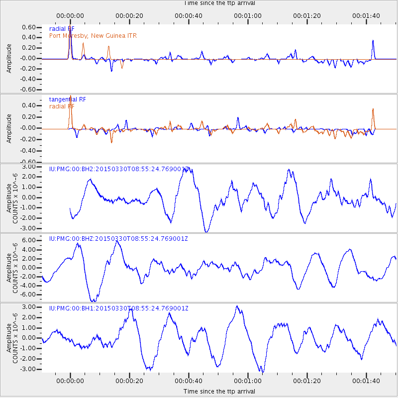
PMG Port Moresby, New Guinea - Earthquake Result Viewer
*The percent match for this event was below the threshold and hence no stack was calculated.
| Earthquake location: |
Samoa Islands Region |
| Earthquake latitude/longitude: |
-15.5/-172.9 |
| Earthquake time(UTC): |
2015/03/30 (089) 08:48:25 GMT |
| Earthquake Depth: |
10 km |
| Earthquake Magnitude: |
6.8 MWB |
| Earthquake Catalog/Contributor: |
NEIC PDE/NEIC COMCAT |
|
| Network: |
IU Global Seismograph Network (GSN - IRIS/USGS) |
| Station: |
PMG Port Moresby, New Guinea |
| Lat/Lon: |
9.40 S/147.16 E |
| Elevation: |
90 m |
|
| Distance: |
39.4 deg |
| Az: |
274.075 deg |
| Baz: |
103.003 deg |
| Ray Param: |
$rayparam |
*The percent match for this event was below the threshold and hence was not used in the summary stack. |
|
| Radial Match: |
69.87034 % |
| Radial Bump: |
400 |
| Transverse Match: |
43.143993 % |
| Transverse Bump: |
306 |
| SOD ConfigId: |
872571 |
| Insert Time: |
2015-04-13 09:07:51.562 +0000 |
| GWidth: |
2.5 |
| Max Bumps: |
400 |
| Tol: |
0.001 |
|
Signal To Noise
| Channel | StoN | STA | LTA |
| IU:PMG:00:BHZ:20150330T08:55:24.769001Z | 1.9393901 | 3.7302273E-6 | 1.9234024E-6 |
| IU:PMG:00:BH1:20150330T08:55:24.769001Z | 1.2075299 | 5.7070304E-7 | 4.7262023E-7 |
| IU:PMG:00:BH2:20150330T08:55:24.769001Z | 1.530174 | 1.3234054E-6 | 8.6487245E-7 |
| Arrivals |
| Ps | |
| PpPs | |
| PsPs/PpSs | |


