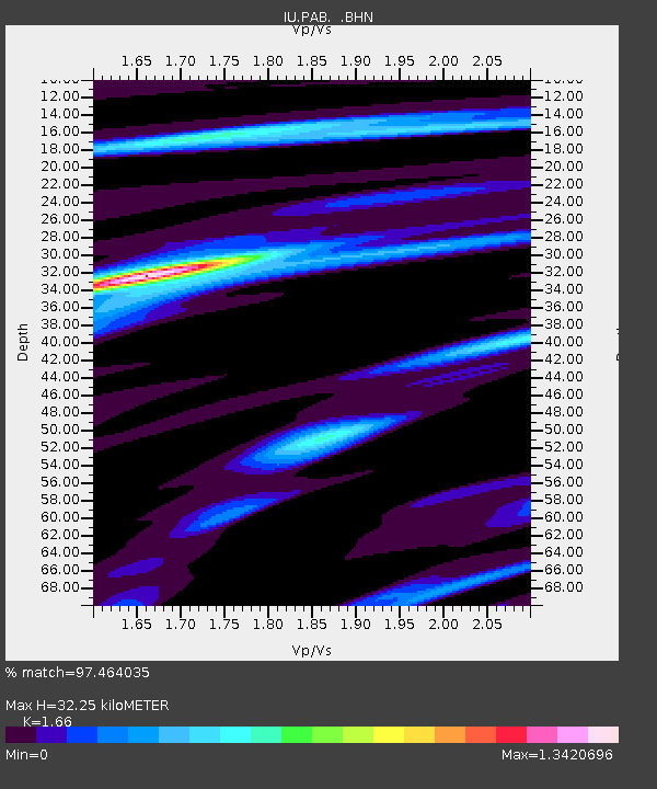
PAB San Pablo, Spain - Earthquake Result Viewer
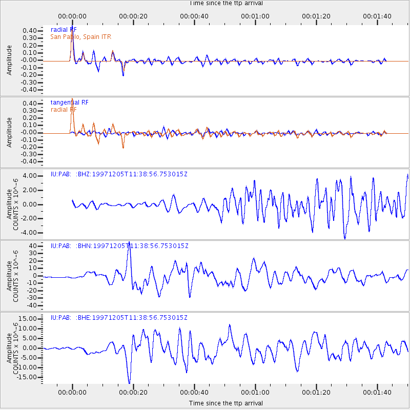
Earthquake location: Near East Coast Of Kamchatka
Earthquake latitude/longitude: 54.8/162.0
Earthquake time(UTC): 1997/12/05 (339) 11:26:54 GMT
Earthquake Depth: 33 km
Earthquake Magnitude: 6.3 MB, 7.6 MS, 7.9 UNKNOWN, 7.3 ME
Earthquake Catalog/Contributor: WHDF/NEIC
Network: IU Global Seismograph Network (GSN - IRIS/USGS)
Station: PAB San Pablo, Spain
Lat/Lon: 39.55 N/4.35 W
Elevation: 925 m
Distance: 85.3 deg
Az: 349.475 deg
Baz: 7.854 deg
Ray Param: 0.044848103
Estimated Moho Depth: 32.25 km
Estimated Crust Vp/Vs: 1.66
Assumed Crust Vp: 6.276 km/s
Estimated Crust Vs: 3.781 km/s
Estimated Crust Poisson's Ratio: 0.22
Radial Match: 97.464035 %
Radial Bump: 377
Transverse Match: 81.46101 %
Transverse Bump: 400
SOD ConfigId: 4480
Insert Time: 2010-03-04 14:32:46.352 +0000
GWidth: 2.5
Max Bumps: 400
Tol: 0.001

Signal To Noise

ChannelStoNSTALTA
IU:PAB: :BHN:19971205T11:38:56.753015Z2.89282872.1895485E-67.568884E-7
IU:PAB: :BHE:19971205T11:38:56.753015Z1.59253538.4366866E-75.297645E-7
IU:PAB: :BHZ:19971205T11:38:56.753015Z3.17102987.657394E-72.414797E-7
Arrivals
Ps3.5 SECOND
PpPs13 SECOND
PsPs/PpSs17 SECOND