You are here: Home > Network List > IU - Global Seismograph Network (GSN - IRIS/USGS) Stations List
> Station PAB San Pablo, Spain > Earthquake Result Viewer
PAB San Pablo, Spain - Earthquake Result Viewer
| Earthquake location: |
Caribbean Sea |
| Earthquake latitude/longitude: |
19.0/-81.4 |
| Earthquake time(UTC): |
2004/12/14 (349) 23:20:13 GMT |
| Earthquake Depth: |
10 km |
| Earthquake Magnitude: |
6.2 MB, 6.7 MS, 6.8 MW, 6.8 MW |
| Earthquake Catalog/Contributor: |
WHDF/NEIC |
|
| Network: |
IU Global Seismograph Network (GSN - IRIS/USGS) |
| Station: |
PAB San Pablo, Spain |
| Lat/Lon: |
39.55 N/4.35 W |
| Elevation: |
925 m |
|
| Distance: |
68.4 deg |
| Az: |
54.162 deg |
| Baz: |
277.125 deg |
| Ray Param: |
0.05634967 |
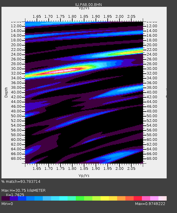
| Estimated Moho Depth: |
30.75 km |
| Estimated Crust Vp/Vs: |
1.76 |
| Assumed Crust Vp: |
6.276 km/s |
| Estimated Crust Vs: |
3.561 km/s |
| Estimated Crust Poisson's Ratio: |
0.26 |
|
| Radial Match: |
93.783714 % |
| Radial Bump: |
400 |
| Transverse Match: |
82.85787 % |
| Transverse Bump: |
400 |
| SOD ConfigId: |
2459 |
| Insert Time: |
2010-03-04 14:33:29.895 +0000 |
| GWidth: |
2.5 |
| Max Bumps: |
400 |
| Tol: |
0.001 |
|

Signal To Noise
| Channel | StoN | STA | LTA |
| IU:PAB:00:BHN:20041214T23:30:43.698013Z | 1.110922 | 1.9472137E-7 | 1.7527906E-7 |
| IU:PAB:00:BHE:20041214T23:30:43.698013Z | 1.1851499 | 3.2774705E-7 | 2.765448E-7 |
| IU:PAB:00:BHZ:20041214T23:30:43.698013Z | 2.3081217 | 6.258349E-7 | 2.7114467E-7 |
| Arrivals |
| Ps | 3.9 SECOND |
| PpPs | 13 SECOND |
| PsPs/PpSs | 17 SECOND |


