You are here: Home > Network List > US - United States National Seismic Network Stations List
> Station WMOK Wichita Mountains, Oklahoma, USA > Earthquake Result Viewer
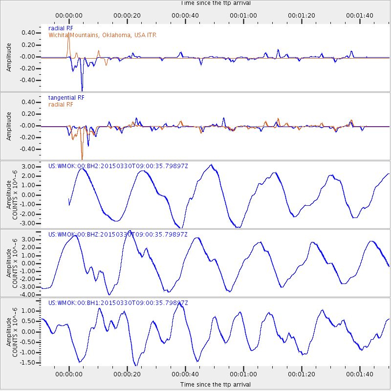
WMOK Wichita Mountains, Oklahoma, USA - Earthquake Result Viewer
*The percent match for this event was below the threshold and hence no stack was calculated.
| Earthquake location: |
Samoa Islands Region |
| Earthquake latitude/longitude: |
-15.5/-172.9 |
| Earthquake time(UTC): |
2015/03/30 (089) 08:48:25 GMT |
| Earthquake Depth: |
10 km |
| Earthquake Magnitude: |
6.8 MWB |
| Earthquake Catalog/Contributor: |
NEIC PDE/NEIC COMCAT |
|
| Network: |
US United States National Seismic Network |
| Station: |
WMOK Wichita Mountains, Oklahoma, USA |
| Lat/Lon: |
34.74 N/98.78 W |
| Elevation: |
486 m |
|
| Distance: |
86.2 deg |
| Az: |
52.554 deg |
| Baz: |
248.309 deg |
| Ray Param: |
$rayparam |
*The percent match for this event was below the threshold and hence was not used in the summary stack. |
|
| Radial Match: |
96.41479 % |
| Radial Bump: |
243 |
| Transverse Match: |
71.39681 % |
| Transverse Bump: |
298 |
| SOD ConfigId: |
872571 |
| Insert Time: |
2015-04-13 09:09:55.769 +0000 |
| GWidth: |
2.5 |
| Max Bumps: |
400 |
| Tol: |
0.001 |
|
Signal To Noise
| Channel | StoN | STA | LTA |
| US:WMOK:00:BHZ:20150330T09:00:35.79897Z | 1.3565594 | 3.5287762E-6 | 2.6012692E-6 |
| US:WMOK:00:BH1:20150330T09:00:35.79897Z | 2.0157144 | 9.277939E-7 | 4.602804E-7 |
| US:WMOK:00:BH2:20150330T09:00:35.79897Z | 0.3319789 | 6.303727E-7 | 1.8988337E-6 |
| Arrivals |
| Ps | |
| PpPs | |
| PsPs/PpSs | |


