You are here: Home > Network List > IU - Global Seismograph Network (GSN - IRIS/USGS) Stations List
> Station PAB San Pablo, Spain > Earthquake Result Viewer
PAB San Pablo, Spain - Earthquake Result Viewer
| Earthquake location: |
Alaska Peninsula |
| Earthquake latitude/longitude: |
55.2/-160.5 |
| Earthquake time(UTC): |
1993/05/13 (133) 11:59:49 GMT |
| Earthquake Depth: |
32 km |
| Earthquake Magnitude: |
6.4 MB, 6.8 MS, 6.8 UNKNOWN |
| Earthquake Catalog/Contributor: |
WHDF/NEIC |
|
| Network: |
IU Global Seismograph Network (GSN - IRIS/USGS) |
| Station: |
PAB San Pablo, Spain |
| Lat/Lon: |
39.55 N/4.35 W |
| Elevation: |
925 m |
|
| Distance: |
83.5 deg |
| Az: |
18.372 deg |
| Baz: |
346.477 deg |
| Ray Param: |
0.0461309 |
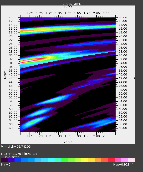
| Estimated Moho Depth: |
32.75 km |
| Estimated Crust Vp/Vs: |
1.63 |
| Assumed Crust Vp: |
6.276 km/s |
| Estimated Crust Vs: |
3.856 km/s |
| Estimated Crust Poisson's Ratio: |
0.20 |
|
| Radial Match: |
96.74103 % |
| Radial Bump: |
400 |
| Transverse Match: |
78.517845 % |
| Transverse Bump: |
400 |
| SOD ConfigId: |
16938 |
| Insert Time: |
2010-03-04 14:35:12.411 +0000 |
| GWidth: |
2.5 |
| Max Bumps: |
400 |
| Tol: |
0.001 |
|
Signal To Noise
| Channel | StoN | STA | LTA |
| IU:PAB: :BHN:19930513T12:11:42.416003Z | 11.498445 | 9.405872E-7 | 8.180126E-8 |
| IU:PAB: :BHE:19930513T12:11:42.416003Z | 3.4417348 | 1.7047982E-7 | 4.9533107E-8 |
| IU:PAB: :BHZ:19930513T12:11:42.416003Z | 33.814762 | 2.4876963E-6 | 7.356836E-8 |
| Arrivals |
| Ps | 3.4 SECOND |
| PpPs | 13 SECOND |
| PsPs/PpSs | 17 SECOND |


