You are here: Home > Network List > ZE15 - Southern Alaska Lithosphere and Mantle Observation Network Stations List
> Station MPEN Moose Pens 2, Alaska > Earthquake Result Viewer
MPEN Moose Pens 2, Alaska - Earthquake Result Viewer
| Earthquake location: |
Kermadec Islands Region |
| Earthquake latitude/longitude: |
-27.4/-176.1 |
| Earthquake time(UTC): |
2015/08/04 (216) 23:21:14 GMT |
| Earthquake Depth: |
31 km |
| Earthquake Magnitude: |
5.3 MW |
| Earthquake Catalog/Contributor: |
ISC/ISC |
|
| Network: |
ZE Southern Alaska Lithosphere and Mantle Observation Network |
| Station: |
MPEN Moose Pens 2, Alaska |
| Lat/Lon: |
60.74 N/150.48 W |
| Elevation: |
124 m |
|
| Distance: |
90.3 deg |
| Az: |
12.266 deg |
| Baz: |
202.611 deg |
| Ray Param: |
0.04168257 |
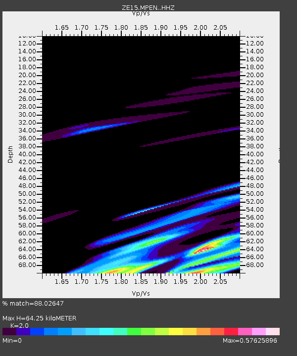
| Estimated Moho Depth: |
64.25 km |
| Estimated Crust Vp/Vs: |
2.00 |
| Assumed Crust Vp: |
6.302 km/s |
| Estimated Crust Vs: |
3.151 km/s |
| Estimated Crust Poisson's Ratio: |
0.33 |
|
| Radial Match: |
88.02647 % |
| Radial Bump: |
251 |
| Transverse Match: |
49.308273 % |
| Transverse Bump: |
400 |
| SOD ConfigId: |
7422571 |
| Insert Time: |
2019-04-20 03:55:37.336 +0000 |
| GWidth: |
2.5 |
| Max Bumps: |
400 |
| Tol: |
0.001 |
|

Signal To Noise
| Channel | StoN | STA | LTA |
| ZE:MPEN: :HHZ:20150804T23:33:41.140Z | 0.63746893 | 2.9057944E-7 | 4.5583312E-7 |
| ZE:MPEN: :HHN:20150804T23:33:41.140Z | 0.84328836 | 3.1266603E-7 | 3.7077E-7 |
| ZE:MPEN: :HHE:20150804T23:33:41.140Z | 1.0075436 | 3.6302097E-7 | 3.6030303E-7 |
| Arrivals |
| Ps | 10 SECOND |
| PpPs | 30 SECOND |
| PsPs/PpSs | 40 SECOND |


