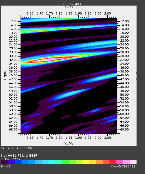
PAB San Pablo, Spain - Earthquake Result Viewer
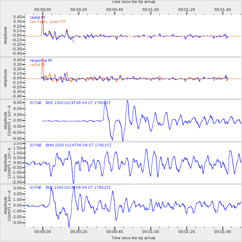
Earthquake location: Near Coast Of Guerrero, Mexico
Earthquake latitude/longitude: 16.8/-98.7
Earthquake time(UTC): 1993/10/24 (297) 07:52:17 GMT
Earthquake Depth: 32 km
Earthquake Magnitude: 6.2 MB, 6.6 MS, 6.5 UNKNOWN, 6.8 MW
Earthquake Catalog/Contributor: WHDF/NEIC
Network: IU Global Seismograph Network (GSN - IRIS/USGS)
Station: PAB San Pablo, Spain
Lat/Lon: 39.55 N/4.35 W
Elevation: 925 m
Distance: 82.8 deg
Az: 50.995 deg
Baz: 285.684 deg
Ray Param: 0.04659654
Estimated Moho Depth: 31.75 km
Estimated Crust Vp/Vs: 1.73
Assumed Crust Vp: 6.276 km/s
Estimated Crust Vs: 3.633 km/s
Estimated Crust Poisson's Ratio: 0.25
Radial Match: 96.506226 %
Radial Bump: 400
Transverse Match: 88.72022 %
Transverse Bump: 400
SOD ConfigId: 16938
Insert Time: 2010-03-04 14:35:51.982 +0000
GWidth: 2.5
Max Bumps: 400
Tol: 0.001

Signal To Noise

ChannelStoNSTALTA
IU:PAB: :BHN:19931024T08:04:07.178015Z4.38807874.5742416E-71.0424247E-7
IU:PAB: :BHE:19931024T08:04:07.178015Z9.93818951.0699146E-61.07656895E-7
IU:PAB: :BHZ:19931024T08:04:07.178015Z32.526133.3760489E-61.0379498E-7
Arrivals
Ps3.8 SECOND
PpPs13 SECOND
PsPs/PpSs17 SECOND