You are here: Home > Network List > IU - Global Seismograph Network (GSN - IRIS/USGS) Stations List
> Station PAB San Pablo, Spain > Earthquake Result Viewer
PAB San Pablo, Spain - Earthquake Result Viewer

| Earthquake location: |
Guerrero, Mexico |
| Earthquake latitude/longitude: |
17.6/-101.0 |
| Earthquake time(UTC): |
1996/07/15 (197) 21:23:34 GMT |
| Earthquake Depth: |
18 km |
| Earthquake Magnitude: |
5.7 MB, 6.5 MS, 6.6 UNKNOWN, 6.2 ME |
| Earthquake Catalog/Contributor: |
WHDF/NEIC |
|
| Network: |
IU Global Seismograph Network (GSN - IRIS/USGS) |
| Station: |
PAB San Pablo, Spain |
| Lat/Lon: |
39.55 N/4.35 W |
| Elevation: |
925 m |
|
| Distance: |
83.9 deg |
| Az: |
50.568 deg |
| Baz: |
287.684 deg |
| Ray Param: |
0.045817748 |
| Estimated Moho Depth: |
30.25 km |
| Estimated Crust Vp/Vs: |
1.80 |
| Assumed Crust Vp: |
6.276 km/s |
| Estimated Crust Vs: |
3.496 km/s |
| Estimated Crust Poisson's Ratio: |
0.27 |
|
| Radial Match: |
98.63152 % |
| Radial Bump: |
270 |
| Transverse Match: |
89.003204 % |
| Transverse Bump: |
400 |
| SOD ConfigId: |
6273 |
| Insert Time: |
2010-03-04 14:37:46.069 +0000 |
| GWidth: |
2.5 |
| Max Bumps: |
400 |
| Tol: |
0.001 |
|
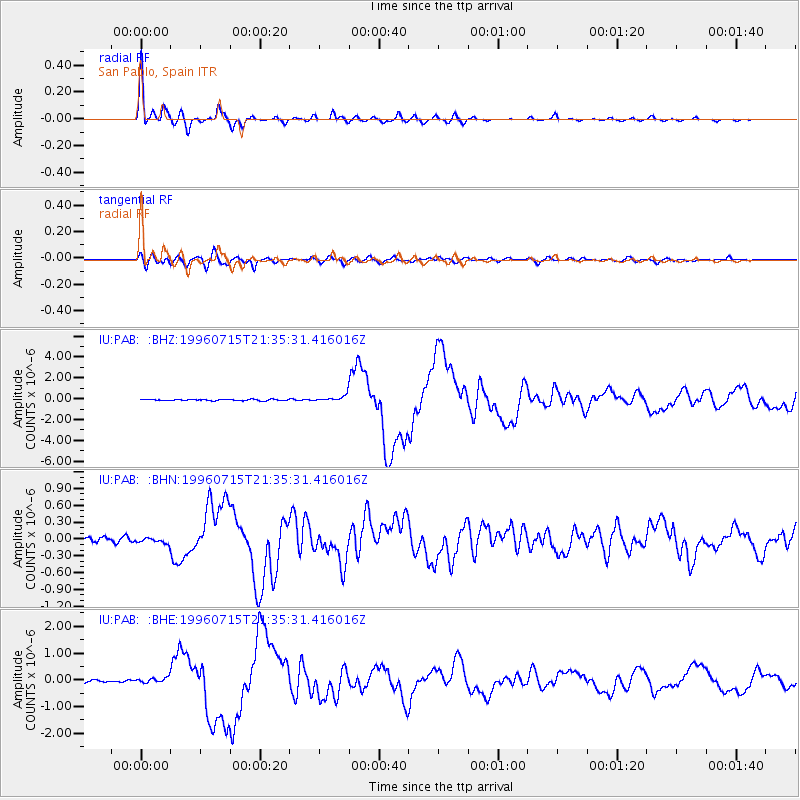
Signal To Noise
| Channel | StoN | STA | LTA |
| IU:PAB: :BHN:19960715T21:35:31.416016Z | 1.3897126 | 5.2490314E-8 | 3.7770626E-8 |
| IU:PAB: :BHE:19960715T21:35:31.416016Z | 2.1561656 | 9.782797E-8 | 4.537127E-8 |
| IU:PAB: :BHZ:19960715T21:35:31.416016Z | 4.2993655 | 2.8759956E-7 | 6.689349E-8 |
| Arrivals |
| Ps | 3.9 SECOND |
| PpPs | 13 SECOND |
| PsPs/PpSs | 17 SECOND |


