You are here: Home > Network List > TA - USArray Transportable Network (new EarthScope stations) Stations List
> Station A21K Barrow, AK, USA > Earthquake Result Viewer
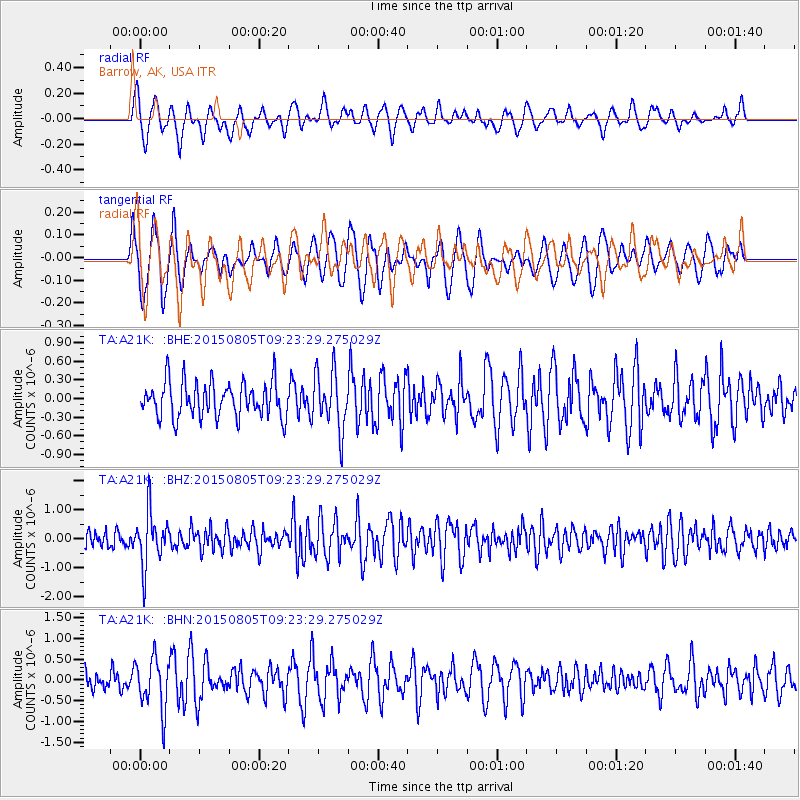
A21K Barrow, AK, USA - Earthquake Result Viewer
*The percent match for this event was below the threshold and hence no stack was calculated.
| Earthquake location: |
Chiapas, Mexico |
| Earthquake latitude/longitude: |
16.2/-93.6 |
| Earthquake time(UTC): |
2015/08/05 (217) 09:13:24 GMT |
| Earthquake Depth: |
110 km |
| Earthquake Magnitude: |
5.7 MWB |
| Earthquake Catalog/Contributor: |
NEIC PDE/NEIC COMCAT |
|
| Network: |
TA USArray Transportable Network (new EarthScope stations) |
| Station: |
A21K Barrow, AK, USA |
| Lat/Lon: |
71.32 N/156.62 W |
| Elevation: |
577 m |
|
| Distance: |
66.3 deg |
| Az: |
341.725 deg |
| Baz: |
110.723 deg |
| Ray Param: |
$rayparam |
*The percent match for this event was below the threshold and hence was not used in the summary stack. |
|
| Radial Match: |
60.84398 % |
| Radial Bump: |
400 |
| Transverse Match: |
63.915714 % |
| Transverse Bump: |
400 |
| SOD ConfigId: |
7422571 |
| Insert Time: |
2019-04-20 04:05:47.973 +0000 |
| GWidth: |
2.5 |
| Max Bumps: |
400 |
| Tol: |
0.001 |
|
Signal To Noise
| Channel | StoN | STA | LTA |
| TA:A21K: :BHZ:20150805T09:23:29.275029Z | 3.057803 | 9.1623565E-7 | 2.9963854E-7 |
| TA:A21K: :BHN:20150805T09:23:29.275029Z | 2.5051775 | 6.183118E-7 | 2.4681356E-7 |
| TA:A21K: :BHE:20150805T09:23:29.275029Z | 1.6579216 | 4.8109445E-7 | 2.9017926E-7 |
| Arrivals |
| Ps | |
| PpPs | |
| PsPs/PpSs | |


