PAB San Pablo, Spain - Earthquake Result Viewer
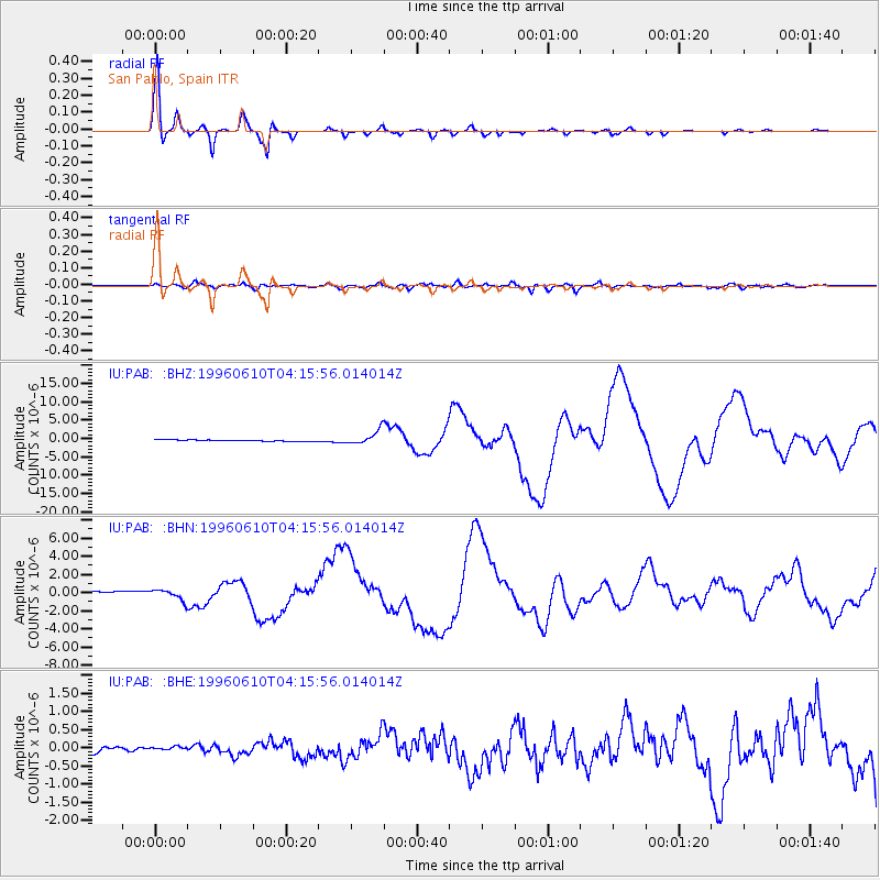
Earthquake location: Andreanof Islands, Aleutian Is.
Earthquake latitude/longitude: 51.6/-177.6
Earthquake time(UTC): 1996/06/10 (162) 04:03:35 GMT
Earthquake Depth: 33 km
Earthquake Magnitude: 6.6 MB, 7.6 MS, 7.9 UNKNOWN, 7.4 MS
Earthquake Catalog/Contributor: WHDF/NEIC
Network: IU Global Seismograph Network (GSN - IRIS/USGS)
Station: PAB San Pablo, Spain
Lat/Lon: 39.55 N/4.35 W
Elevation: 925 m
Distance: 89.1 deg
Az: 5.189 deg
Baz: 355.813 deg
Ray Param: 0.042072408
Estimated Moho Depth: 33.5 km
Estimated Crust Vp/Vs: 1.63
Assumed Crust Vp: 6.276 km/s
Estimated Crust Vs: 3.844 km/s
Estimated Crust Poisson's Ratio: 0.20
Radial Match: 98.34587 %
Radial Bump: 257
Transverse Match: 86.878265 %
Transverse Bump: 400
SOD ConfigId: 6273
Insert Time: 2010-03-04 14:37:55.555 +0000
GWidth: 2.5
Max Bumps: 400
Tol: 0.001

Signal To Noise

ChannelStoNSTALTA
IU:PAB: :BHN:19960610T04:15:56.014014Z5.73494865.899332E-71.02866345E-7
IU:PAB: :BHE:19960610T04:15:56.014014Z0.680153254.4556717E-86.550982E-8
IU:PAB: :BHZ:19960610T04:15:56.014014Z8.7618591.8104216E-62.0662529E-7
Arrivals
Ps3.5 SECOND
PpPs14 SECOND
PsPs/PpSs17 SECOND