You are here: Home > Network List > TA - USArray Transportable Network (new EarthScope stations) Stations List
> Station I23K Minto, Yukon-Koyukuk, AK, USA > Earthquake Result Viewer
I23K Minto, Yukon-Koyukuk, AK, USA - Earthquake Result Viewer
| Earthquake location: |
Chiapas, Mexico |
| Earthquake latitude/longitude: |
16.2/-93.6 |
| Earthquake time(UTC): |
2015/08/05 (217) 09:13:24 GMT |
| Earthquake Depth: |
110 km |
| Earthquake Magnitude: |
5.7 MWB |
| Earthquake Catalog/Contributor: |
NEIC PDE/NEIC COMCAT |
|
| Network: |
TA USArray Transportable Network (new EarthScope stations) |
| Station: |
I23K Minto, Yukon-Koyukuk, AK, USA |
| Lat/Lon: |
65.15 N/149.36 W |
| Elevation: |
149 m |
|
| Distance: |
61.4 deg |
| Az: |
336.548 deg |
| Baz: |
115.18 deg |
| Ray Param: |
0.060621656 |
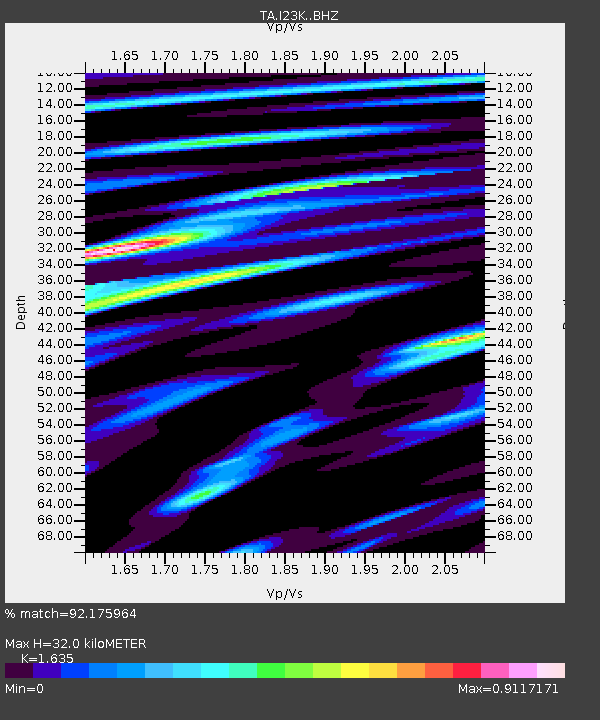
| Estimated Moho Depth: |
32.0 km |
| Estimated Crust Vp/Vs: |
1.63 |
| Assumed Crust Vp: |
6.566 km/s |
| Estimated Crust Vs: |
4.016 km/s |
| Estimated Crust Poisson's Ratio: |
0.20 |
|
| Radial Match: |
92.175964 % |
| Radial Bump: |
400 |
| Transverse Match: |
87.419235 % |
| Transverse Bump: |
400 |
| SOD ConfigId: |
7422571 |
| Insert Time: |
2019-04-20 04:06:06.223 +0000 |
| GWidth: |
2.5 |
| Max Bumps: |
400 |
| Tol: |
0.001 |
|
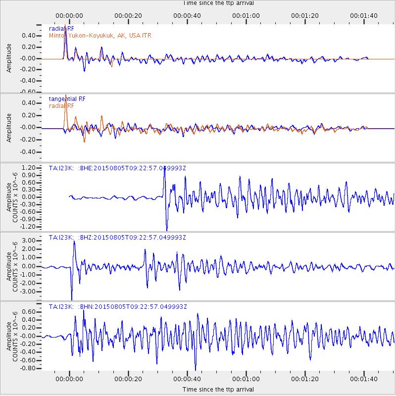
Signal To Noise
| Channel | StoN | STA | LTA |
| TA:I23K: :BHZ:20150805T09:22:57.049993Z | 21.629911 | 1.4037488E-6 | 6.48985E-8 |
| TA:I23K: :BHN:20150805T09:22:57.049993Z | 6.510269 | 2.7043342E-7 | 4.153951E-8 |
| TA:I23K: :BHE:20150805T09:22:57.049993Z | 15.41286 | 5.8173737E-7 | 3.7743636E-8 |
| Arrivals |
| Ps | 3.3 SECOND |
| PpPs | 12 SECOND |
| PsPs/PpSs | 15 SECOND |


