You are here: Home > Network List > IU - Global Seismograph Network (GSN - IRIS/USGS) Stations List
> Station PAB San Pablo, Spain > Earthquake Result Viewer
PAB San Pablo, Spain - Earthquake Result Viewer

| Earthquake location: |
Southern Bolivia |
| Earthquake latitude/longitude: |
-22.0/-65.7 |
| Earthquake time(UTC): |
1997/01/23 (023) 02:15:22 GMT |
| Earthquake Depth: |
276 km |
| Earthquake Magnitude: |
6.4 MB, 7.1 UNKNOWN, 7.1 MW |
| Earthquake Catalog/Contributor: |
WHDF/NEIC |
|
| Network: |
IU Global Seismograph Network (GSN - IRIS/USGS) |
| Station: |
PAB San Pablo, Spain |
| Lat/Lon: |
39.55 N/4.35 W |
| Elevation: |
925 m |
|
| Distance: |
83.8 deg |
| Az: |
43.05 deg |
| Baz: |
235.02 deg |
| Ray Param: |
0.045222677 |
| Estimated Moho Depth: |
32.25 km |
| Estimated Crust Vp/Vs: |
1.67 |
| Assumed Crust Vp: |
6.276 km/s |
| Estimated Crust Vs: |
3.758 km/s |
| Estimated Crust Poisson's Ratio: |
0.22 |
|
| Radial Match: |
93.31182 % |
| Radial Bump: |
400 |
| Transverse Match: |
85.06298 % |
| Transverse Bump: |
400 |
| SOD ConfigId: |
6273 |
| Insert Time: |
2010-03-04 14:37:57.379 +0000 |
| GWidth: |
2.5 |
| Max Bumps: |
400 |
| Tol: |
0.001 |
|
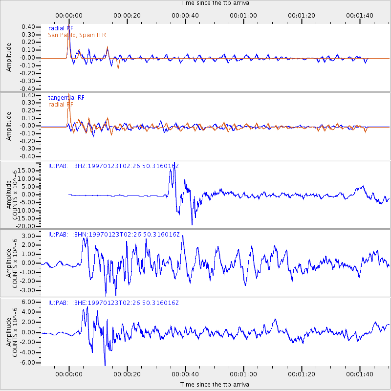
Signal To Noise
| Channel | StoN | STA | LTA |
| IU:PAB: :BHN:19970123T02:26:50.316016Z | 4.771812 | 6.060992E-7 | 1.2701658E-7 |
| IU:PAB: :BHE:19970123T02:26:50.316016Z | 6.87913 | 1.050446E-6 | 1.5270042E-7 |
| IU:PAB: :BHZ:19970123T02:26:50.316016Z | 18.263191 | 3.6614563E-6 | 2.0048284E-7 |
| Arrivals |
| Ps | 3.5 SECOND |
| PpPs | 13 SECOND |
| PsPs/PpSs | 17 SECOND |


