You are here: Home > Network List > TA - USArray Transportable Network (new EarthScope stations) Stations List
> Station J20K Nowitna River, AK, USA > Earthquake Result Viewer
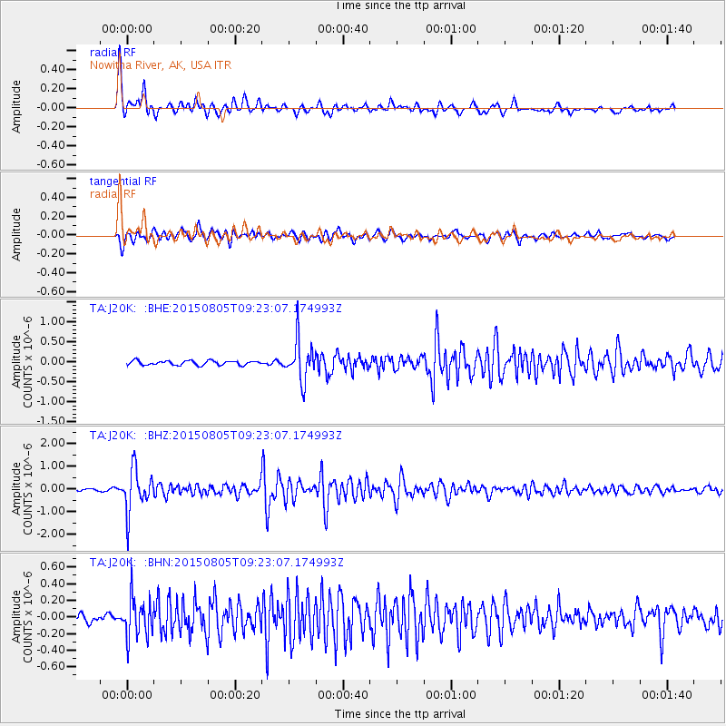
J20K Nowitna River, AK, USA - Earthquake Result Viewer
*The percent match for this event was below the threshold and hence no stack was calculated.
| Earthquake location: |
Chiapas, Mexico |
| Earthquake latitude/longitude: |
16.2/-93.6 |
| Earthquake time(UTC): |
2015/08/05 (217) 09:13:24 GMT |
| Earthquake Depth: |
110 km |
| Earthquake Magnitude: |
5.7 MWB |
| Earthquake Catalog/Contributor: |
NEIC PDE/NEIC COMCAT |
|
| Network: |
TA USArray Transportable Network (new EarthScope stations) |
| Station: |
J20K Nowitna River, AK, USA |
| Lat/Lon: |
64.18 N/154.15 W |
| Elevation: |
314 m |
|
| Distance: |
62.9 deg |
| Az: |
334.636 deg |
| Baz: |
109.964 deg |
| Ray Param: |
$rayparam |
*The percent match for this event was below the threshold and hence was not used in the summary stack. |
|
| Radial Match: |
91.27553 % |
| Radial Bump: |
400 |
| Transverse Match: |
86.26709 % |
| Transverse Bump: |
400 |
| SOD ConfigId: |
7422571 |
| Insert Time: |
2019-04-20 04:06:11.924 +0000 |
| GWidth: |
2.5 |
| Max Bumps: |
400 |
| Tol: |
0.001 |
|
Signal To Noise
| Channel | StoN | STA | LTA |
| TA:J20K: :BHZ:20150805T09:23:07.174993Z | 18.06671 | 9.248322E-7 | 5.1189858E-8 |
| TA:J20K: :BHN:20150805T09:23:07.174993Z | 4.44153 | 2.3947118E-7 | 5.3916366E-8 |
| TA:J20K: :BHE:20150805T09:23:07.174993Z | 9.756759 | 5.097749E-7 | 5.224839E-8 |
| Arrivals |
| Ps | |
| PpPs | |
| PsPs/PpSs | |


